Emlid Reach GNSS Receiver

TitleMany possibilities at a small price
Emlid is a leading manufacturer of GNSS (Global Navigation Satellite System) receivers that provide precise positioning data for a wide range of applications. Emlid receivers are characterized by their high accuracy, reliability and ease of use. These devices are widely used in areas such as surveying, mapping, agriculture and drone navigation and enable extremely precise positioning thanks to RTK and PPK (Real-Time Kinematic and Post-Processed Kinematic) technologies.
TitleGNSS systems for a variety of requirements
With the Reach RS3 from Emlid, you can explore new paths and measure previously inaccessible positions. The integrated tilt sensor opens up a wide range of possibilities for quick and easy GNSS measurements.
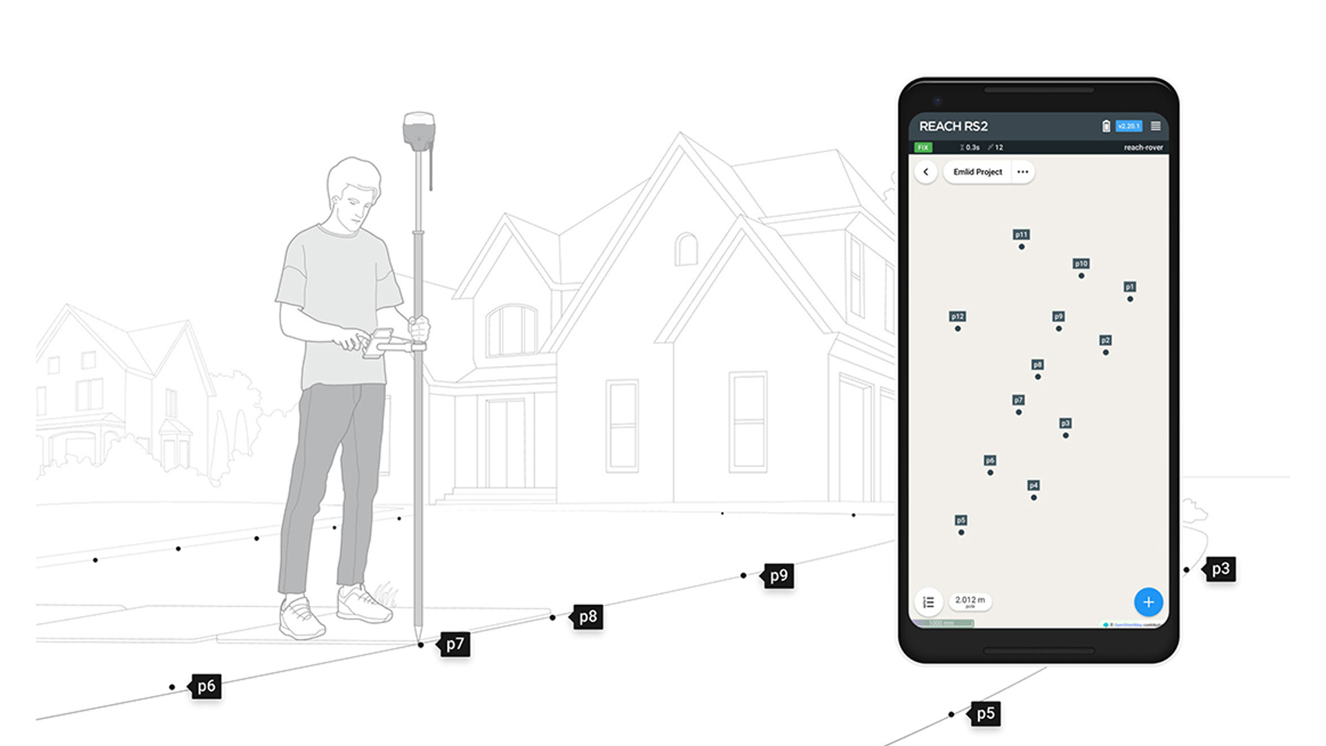
The Emlid Reach RS2+ is the ideal device for quick and uncomplicated GNSS measurements. By receiving signals from several satellite systems, highly accurate positioning is possible in the shortest possible time. It is easy to control using your own smartphone instead of heavy and unwieldy field computers.
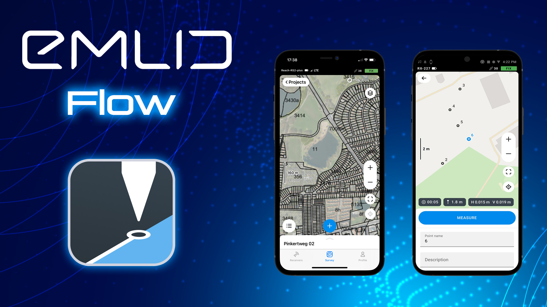
The free Emlid Flow app is available for iOS and Android operating systems and offers the most important functions for taking satellite-based measurements. It is possible to measure points in the field. In addition, imported points can also be staked out on site.
The integration possibilities with other Emlid products as well as other providers are extensive. The Reach RS+ and RS2+ can be used both as a rover and as a base.
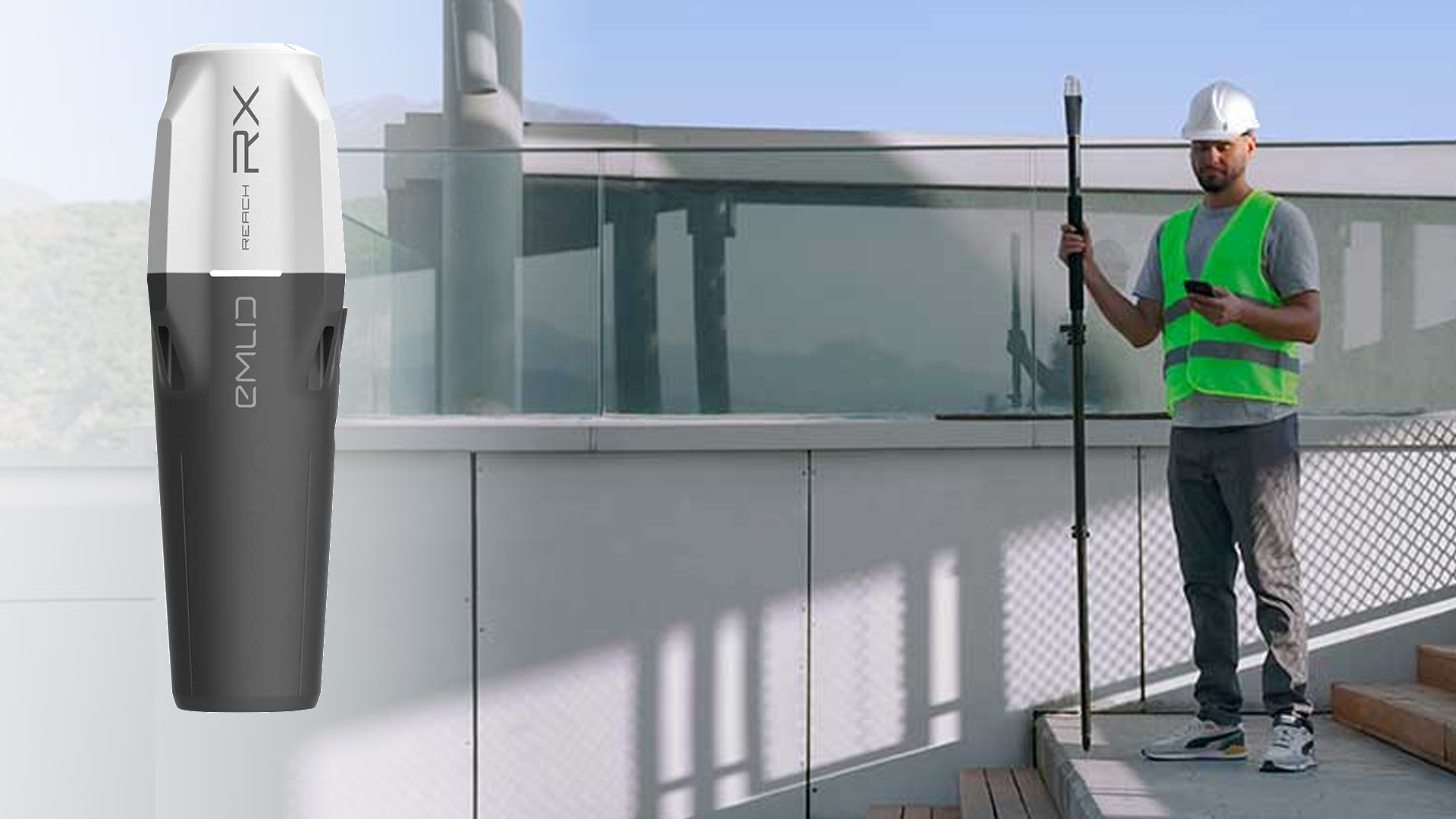
The Reach RX is the smallest and lightest (only 250g !!!) GNSS receiver in the EMLID product range and delivers centimeter accuracy even under difficult conditions.

TitleEmlid Reach RS3
The Emlid Reach RS3 features state-of-the-art IMU tilt compensation, enabling survey-quality data capture in hard-to-reach places such as corners of buildings, under vehicles, etc. This Emlid proprietary technology provides industry-leading accuracy of RTK + 2mm + 0.3mm/degree, all with a factory calibrated IMU for seamless out-of-the-box functionality.
The Reach RS3 tracks GPS/QZSS, GLONASS, BeiDou, Galileo E1, E5 and finds a position in under 5 seconds, even under difficult conditions. The new RTK GNSS receiver with integrated LTE modem is characterized in particular by a high level of user-friendliness and use in difficult conditions. Thanks to IP67, the device is protected against dust and water (to a depth of 1m), can be used at temperatures from -20°C to +65°C and is particularly resistant to shocks thanks to the high-quality polycarbonate housing.
TitleEmlid Reach RX
The Reach RX is a multi-band network rover that focuses on user-friendliness. It is easy to set up via Bluetooth; almost no configuration is required. Simply add the network correction data (NTRIP) and start surveying within seconds.
Small and extremely lightweight, the Reach RX fits in any pocket, so you can take it almost anywhere to survey points with RTK to centimeter accuracy in seconds. The Reach RX tracks GPS/QZSS, Galileo, GLONASS and BeiDou and finds a position in under 5 seconds, even in difficult conditions.
The Emlid Reach RX is available as a bundle for mobile scanning.
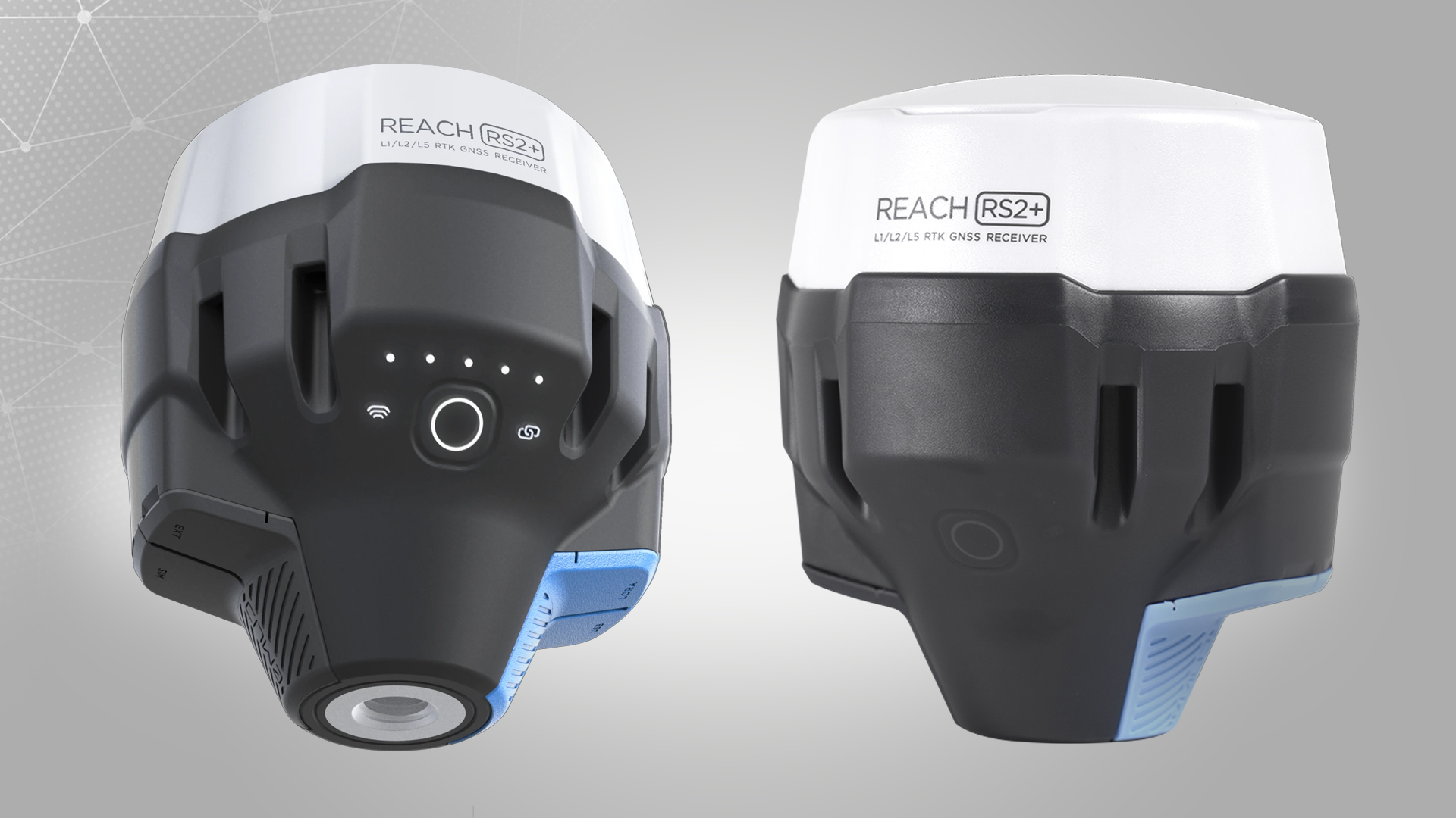
TitleEmlid Reach RS2+
The Reach RS2+ is the high-end solution for cost-effective measurements of coordinates anywhere in the world. It receives satellite signals from a wide range of providers (GPS, GLONASS, Galileo, ... ) and thus obtains positioning with centimeter accuracy within a few seconds. The correction data required can be obtained from a self-built base station via LoRa or from correction data providers via the Internet. The internet connection is established conventionally by an insertable SIM card, or even more simply via Wi-Fi hotspot, from a smartphone.
The rugged housing and long battery life make the RS2 the ideal outdoor professional. It defies extreme temperature and weather conditions thanks to its IP67 certification.
With the help of standard output formats, the Reach RS2 can also be used in conjunction with other GNSS receivers. Correction data can be provided via a wide variety of options using the standardized RTCM3 transmission format. The transmission of coordinates in NMEA format to further software or hardware is also supported. For post-processing of the coordinates, you can also save the raw data of the measurement in RINEX format.
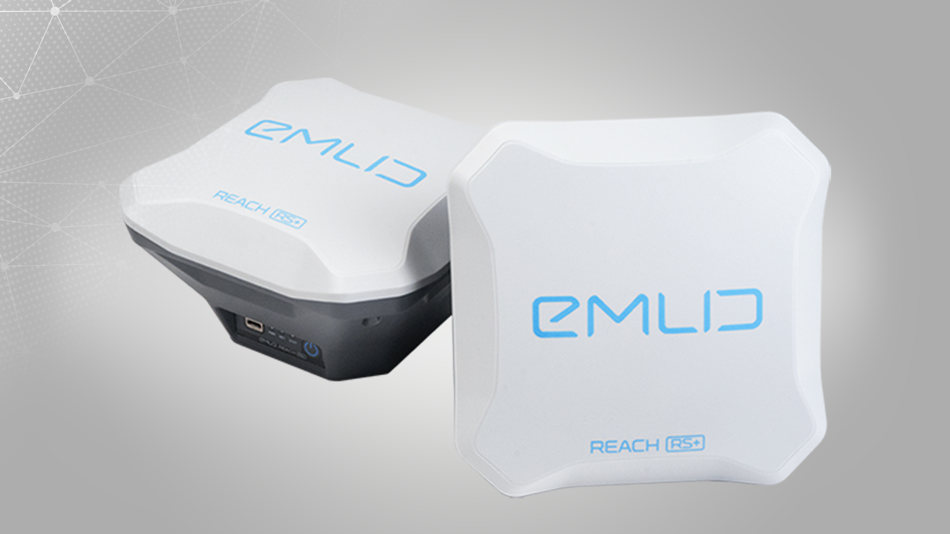
TitleEmlid Reach RS+
The Emlid Reach RS+ is the slightly cheaper version of the RS2, but is still a high-quality GNSS receiver. The RS+ is a single-band receiver, which can lead to slightly less stable measurements, especially in difficult conditions.
The internet connection when used as an RTK rover is only possible via the WiFi function. The RS+ is slightly less accurate than the RS2, especially if it is further than 10 km away from reference stations.
The Reach RS+ can be operated well with the RS2 or other GNSS modules in a base-rover combination. By transmitting correction data to the rover via LoRa radio, the RS+ can also achieve high repeatable accuracies.
TitleEmlid Flow
The control of all Emlid GNSS receivers is realized via the Emlid Flow App. The latest version is the Emlid Flow App, which has been available for iOS and Android operating systems.
TitleUmfang der Emlid FLow App
The Emlid Flow app offers the following options:
- Easy measurement of points in different coordinate systems
- Export of measurement data in .csv format
- Import of measurement points into the project in .csv format
- Staking out points with live direction indicators
- Configuration of the rover
- Configuration of base-rover combinations
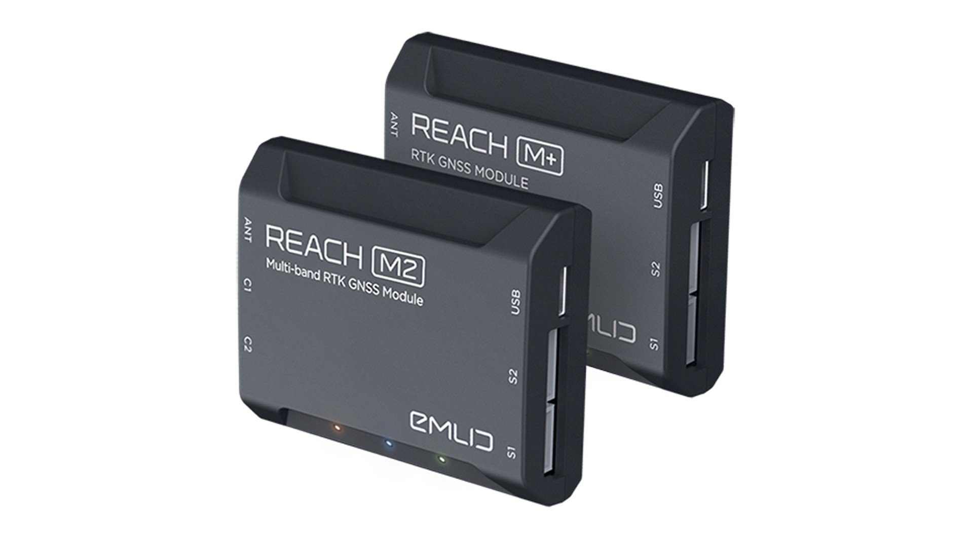
TitleEmlid GNSS modules
The Reach M2 and Reach M+ GNSS modules are used for a wide range of applications and for integration into existing hardware solutions. The main area of application is aerial photography with the help of UAVs, where flight routes can be made more precise or photogrammetric images can be geo-tagged directly during creation. Thus, errors in post-processing can be prevented.
With numerous accessories, the modules can also operate as low-budget RTK receivers. These modules can also be applied as a base rover combination with other Emlid products. They can thus also be integrated into various systems where GNSS modules are required.
TitleWide range of applications for Emlid GNSS receivers
Satellite-based measurement of geodetic and topographic points and geometries using GNSS receivers is used in a number of areas:
- Surveying and staking out of construction projects
- Georeferencing of laser scanning projects
- Landmark search
- Integration into tracking systems (agriculture, motor sports, ... )
- Primeval terrain surveys
- UAV mapping
- Others

TitleSimple satellite-based measurements without complex technology
Emlid receivers and modules are ready for use within a few minutes without time-consuming setup or booting of the hardware. With the help of one's own smartphone, all relevant settings of the devices can be made. It also controls them and provides an internet connection for the receiver. Optionally, a tablet, mobile computer or further smartphone can also be used for control.
Depending on the application, quick measurements over a shorter observation period as well as measurements over a longer time can be set to make results more precise. In addition to the measuring mode, the stakeout function can also be used to find and measure imported point lists in the field.
If the functions of the simple in-house Emlid Flow software are not sufficient, the measurements can also be made and expanded with the help of other common apps. In this way, point codes can also be realized and geometries acquired.
Project data is saved either on the control unit or the receiver and can be transferred to the computer with just a few actions.
TitleEmlid Flow app for GPS surveying
The Emlid Flow app is a software solution specifically designed to work with Emlid GNSS receivers, such as the Reach RS3 and Reach RX. It is used to control these devices, collect data and process the collected GPS data. The app can be downloaded from Android and Apple and is available both free of charge and as a subscription.
You can get an annual subscription to the Emlid Flow Survey app here:

TitleEmlid Flow versions
Emlid Flow – free version
- Collect and stake out points
- Coordinate systems, geoids and grid shifts
- base shifts
- Export and import in CSV, DXF and SHP
- Integrated NTRIP client
- Full control over Reach receivers
Emlid Flow360 Cloud
- Project management and automatic synchronization
- Export and import of survey data
The free Emlid Flow app is perfect for simple projects that only require points or post-processing.
Emlid Flow Survey
- Line capture and staking
- Add survey codes on the move
- Use WMS/WMTS layers
- Satellite maps
- Localization
- Inverse and traverse
- Stakeout reports
Emlid Flow 360 Cloud
- Upload code libraries
- Satellite maps
- Use WMS/WMTS layers
- Inverse and traverse
- Stakeout reports
The Emlid Flow Survey is for advanced survey work. All the benefits of the free version are included.
A single subscription for Emlid Flow and Emlid Flow 360.
The following video explains the differences between the free version of the Emlid Flo app and the Emlid Flow Survey in more detail.
TitleTechnical specifications
| Reach RS3 | Reach RS2+ | Reach RS+ | Reach M2 | Reach M+ | |
|---|---|---|---|---|---|
| System configuration | |||||
| Internal storage | 16GB | 16GB | 8GB | 16GB | 8GB |
| Integrated battery | Li-Ion 5200mAh, 7.2V, 37.44Wh | LiFePO4 battery 6400mAh, up to 16 hrs operating time with RTK | yes, up to 30 hrs operating time | no | no |
| Characteristics | |||||
| Dimensions | 126mm x 126mm x 142mm | 126mm x 126mm x 142mm | 145mm x 145mm x 85mm | 56.4mm x 45.3mm x 14.6mm | 56.4mm x 45.3mm x 14.6mm |
| Weight | 950g | 950g | 690g | 35g | 35g |
| Operating temperature | -20°C to +65°C | -20°C to +65°C | -20°C to +65°C | -20°C to +65°C | -20°C tos +65°C |
| Ingress protection | IP67 (protection against dust and water) | IP67 (protection against dust and water) | IP67 (protection against dust and water) | - | - |
| Range | up to 8km | up to 8km | up to 8km | up to 8km | up to 8km |
| Data communication | |||||
| Ports | USB, RS232 | USB, RS232 | USB, RS232 | USB UART, Event | USB, RS232 |
| Radio | LoRa 868/915 MHz | UHF LoRa 868/915MHz, bis 8km | LoRa862-1020MHz | LoRa862-1020Mhz * | LoRa862-1020Mhz * |
| WLAN | 802.11 b/g/n | 802.11 b/g/n | 802.11 b/g/n | 802.11 b/g/n | 802.11 b/g/n |
| Bluetooth | 4.0/2.1 EDR | 4.0/2.1 EDR | 4.0/2.1 EDR | 4.0/2.1 EDR | 4.0/2.1 EDR |
| Mobile data | LTE Modem, Quad-Band, UMTS, Nano-Sim | 4G Modem, Quad-Band, Nano-Sim | - | - | - |
| GNSS function | |||||
| GPS | L1C/A, L2C | L1C/A, L2C | L1 | L1, L2 | L1 |
| GLONASS | L1OF, L2OF | L1OF, L2OF | G1 | G1, G2 | G1 |
| BeiDou | B1I, B2I | B1I, B2I | B1 | B1, B2 | B1 |
| Galileo | E1-B/C, E5b | E1-B/C, E5b | E1 | E1, E5b | E1 |
| SBAS | - | - | SBAS | - | SBAS |
| RTK accuracy | 7mm +1ppm 2mm + 0.3mm/° | 7mm +1ppm | < 10cm | < 5cm | <10cm |
| IMU accuracy | 2mm + 0.3mm/° | - | - | - | - |
| Correction data | NTRIP, RTCM3 | NTRIP, RTCM3 | RTCM2, RTCM3 | RTCM2, RTCM3 | RTCM2, RTCM3 |
| Output | NMEA, LLH/XYZ | NMEA, LLH/XYZ | NMEA, ERB, Text | NMEA, LLH/XYZ | NMEA, LLH/XYZ |
Better advice for users
Are you interested in our offer or would you like to find out more about Emlid GNSS products? Then give us a call today and arrange a free, non-binding consultation. We will answer all your questions. As both a dealer and a user, we are ideally positioned to support you after your purchase.