LiDAR360
TitleProfessional software for the post-processing of point clouds
LiDAR360 is a specialized software that focuses on the processing and analysis of LiDAR (Light Detection and Ranging) data. This software was developed by GreenValley International (GVI) and is designed to provide a comprehensive range of tools and functions required to manage, process and analyze LiDAR data.
TitleMain functions of LiDAR360
TitleData management and visualization
Import and export: Support for various LiDAR data formats such as LAS, LAZ and others.
3D visualization: Enables 3D visualization of point clouds for detailed analysis and presentation.
Point cloud processing: Tools for filtering, segmenting and classifying point clouds.
TitleTerrain analysis
Digital elevation models: Creation and analysis of DEMs based on LiDAR data.
Terrain models: Generation of digital terrain models (DTM) and digital surface models (DSM).
Detection of terrain changes: Identification and analysis of terrain changes over different points in time.
TitleForestry applications
Tree detection and measurement: Automatic detection and measurement of trees and forest stands.
Biomass and carbon estimation: Estimation of biomass and carbon stocks based on LiDAR data.
TitleUrban planning and construction
3D city models: Creation of detailed 3D models of urban areas.
Construction progress monitoring: Monitoring and documentation of construction projects using regular LiDAR scans.
TitleHydrological analyses
Watershed analysis: Determination and analysis of water catchment areas.
Flood and erosion modeling: Prediction and analysis of flood and erosion hazards.
TitleClassification and segmentation
Automatic classification: Tools for automatic classification of point clouds (e.g. vegetation, buildings, soil).
User-defined classification: Possibility to create user-defined classification rules and categories.
TitleUser-friendliness and integration
LiDAR360 is known for its ease of use and ability to efficiently process large amounts of LiDAR data. The software offers an intuitive user interface and extensive documentation to help users get started. LiDAR360 also integrates with various GIS and CAD platforms, facilitating interoperability and data exchange. The powerful and versatile software with its extensive features makes it a valuable tool for professionals in the fields of environmental science, urban planning, forestry and more.
TitleLiDAR360 requirements
System requirements
- Windows 7 (64 bit), 8 (64 bit), 10 (64 bit) oder 11 (64 bit)
- Minimum 8GB RAM
- Processor: Intel® Core i5 or i7, Dual Core
- Graphics card: NVIDIA GTX970 or higher, video memory min. 4GB
Program interface can be set in the following languages
- English
- Chinese
- French
- Japanese

TitlePoint cloud data from various LiDAR measuring devices
The software uses more than 10 internationally leading algorithms for processing point clouds as well as artificial intelligence and machine learning. LiDAR360 can process point cloud data at TB level simultaneously and precisely merge data from multiple sources (point clouds, images, rasters, vectors, models). It offers more than 700 functions to efficiently support a wide range of applications in the fields of terrain, forestry, mining, power grids and more.
TitleProcess huge amounts of data intuitively & intelligently
LiDAR360 is able to process and colorize large amounts of data. The software supports the processing of over 300GB of data under normal conditions, making it ideal for large-scale projects and extensive data sets. This capability ensures that even complex and detailed analyses can be carried out efficiently.
Another outstanding feature of LiDAR360 is its ease of use. The software can be installed with just one click and offers an intuitive and user-friendly interface. It also has various automatic processing functions that help users to achieve the desired results quickly and easily.
Thanks to this combination of leading algorithms, extensive experience, support for mass data processing and ease of use, LiDAR360 is a first-class solution for the diverse requirements of LiDAR data processing.
TitleLiDAR360 data formats at a glance
Supported import formats
- Point cloud: Own LiData file (*.LiData), LAS file (*.las, *.laz.), ASCII file (*.txt, *.asc, *.neu, *.xyz, *.pts, *.csv), PLY file (*.ply), *.e57, *.pcd
- Raster: image file (*.tif, *.jpg)
- Vector: vector file (*.shp, *.dxf, *.kml, *.gpkg)
- Table: Table file (*.csv)
- Model: Own LiData file (*.LiModel), Own TIN file (*.LiTin, *.LiBIM, *.LiTree), OSGB model file (*.osg, *.ive, *.desc, *.obj, *.dxf)
- Trajectory: *.out, *.pos, *.txt
- Aero triangulation: (*.Liaep, *.Ligeo, *.Limap, *.p4d, *.prj)
Supported export formats
- Point cloud: Own LiData file (*.LiData), LAS file (*.las, *.laz), ASCII file (*.txt, *.asc, *.neu, *.xyz, *.pts, *.csv), PLY file (*.ply), *.e57, *.pcd
- Raster: Image file (*.tif, *.jpg)
- Vector: vector file (*.shp, *.dxf, *.kml, *.gpkg)
- Table: Table file (*.csv)
- Model: Own LiData file (*.LiModel), Own TIN file (*.LiTin, *.LiBIM, *.LiTree)

TitleExtensive range of possible applications
LiDAR360 can be used for a wide range of applications. For example, the software has been developed for the following applications:
- Forestry
- Topographical analyses
- City planning
- Infrastructure
- Public utilities
- Geological analyses
- Mining
- Environmental monitoring
- Disaster management
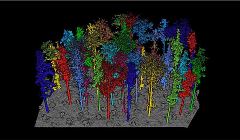
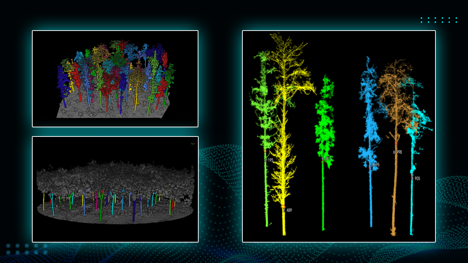
TitleForestry
LiDAR offers unique advantages for forestry inventories. Based on LiDAR point cloud data, LiDAR360 can automatically extract forest parameters such as tree canopy density and deforestation rate, as well as individual tree attributes such as tree height, trunk diameter and crown size, and perform intelligent statistical analysis to support plot investigation, carbon storage detection and other applications, providing unparalleled support for forest resource surveys.
Inventory of forest resources
LiDAR360 can automatically detect and measure trees, including determining tree heights, crown diameters and volumes. This information is essential for sustainable forest management and timber harvest planning.
Biomass and carbon estimation
The software enables the estimation of above-ground biomass and carbon content of forests. This is important for the assessment of carbon storage and the development of climate protection strategies.
Forest growth and protection
By analyzing LiDAR data, foresters can detect changes in forest structure and signs of pest infestation or disease in order to take early countermeasures.
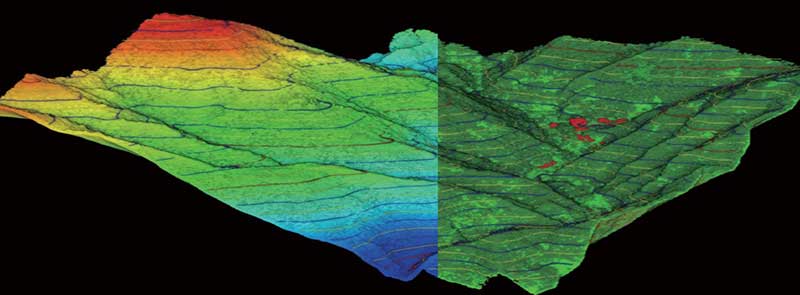
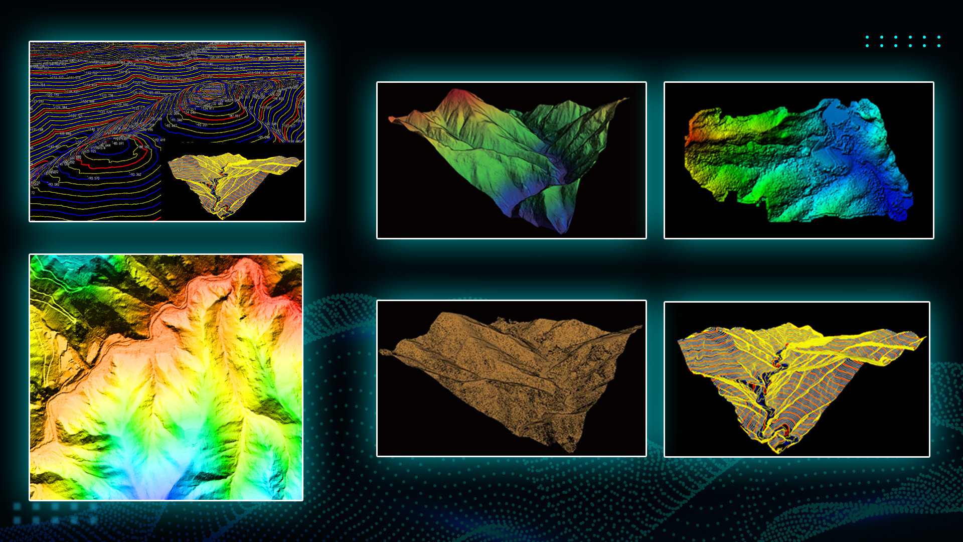
TitleTopographical mapping
LiDAR technology can capture the surface of the ground and generate high-precision point clouds of the terrain in a short time, enabling fast, cost-effective and large-scale ground measurements.
LiDAR360 can automate the processing of terrain measurement data, obtain accurate information about terrain and landscape features, generate various measurement results and high-precision models required for commercial applications, and provide a wealth of analysis tools to improve the quality and efficiency of terrain surveying.
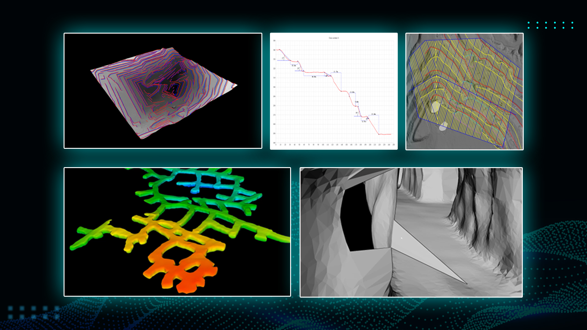
Engineering surveying
With LiDAR360, the over- and under-excavation of earth volumes can be quickly analyzed and survey sections obtained in real time. This is particularly useful for construction projects where accurate volume calculations and continuous monitoring are crucial.
The software can be used in many areas such as road construction, rail surveying, urban redevelopment and hydraulic engineering.
Comprehensive topographical information
With LiDAR360, you can create high-precision digital elevation models, surface models, contour lines and more based on LiDAR point clouds. The software analyzes terrain slope, slope direction and mountain shadows and performs quality checks on the data results. These comprehensive results fulfill the requirements of terrain mapping and provide support for cross-industry applications. These surveys and data evaluations are very important for road construction and building statics.
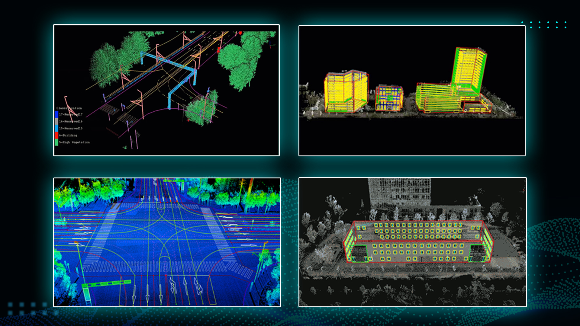
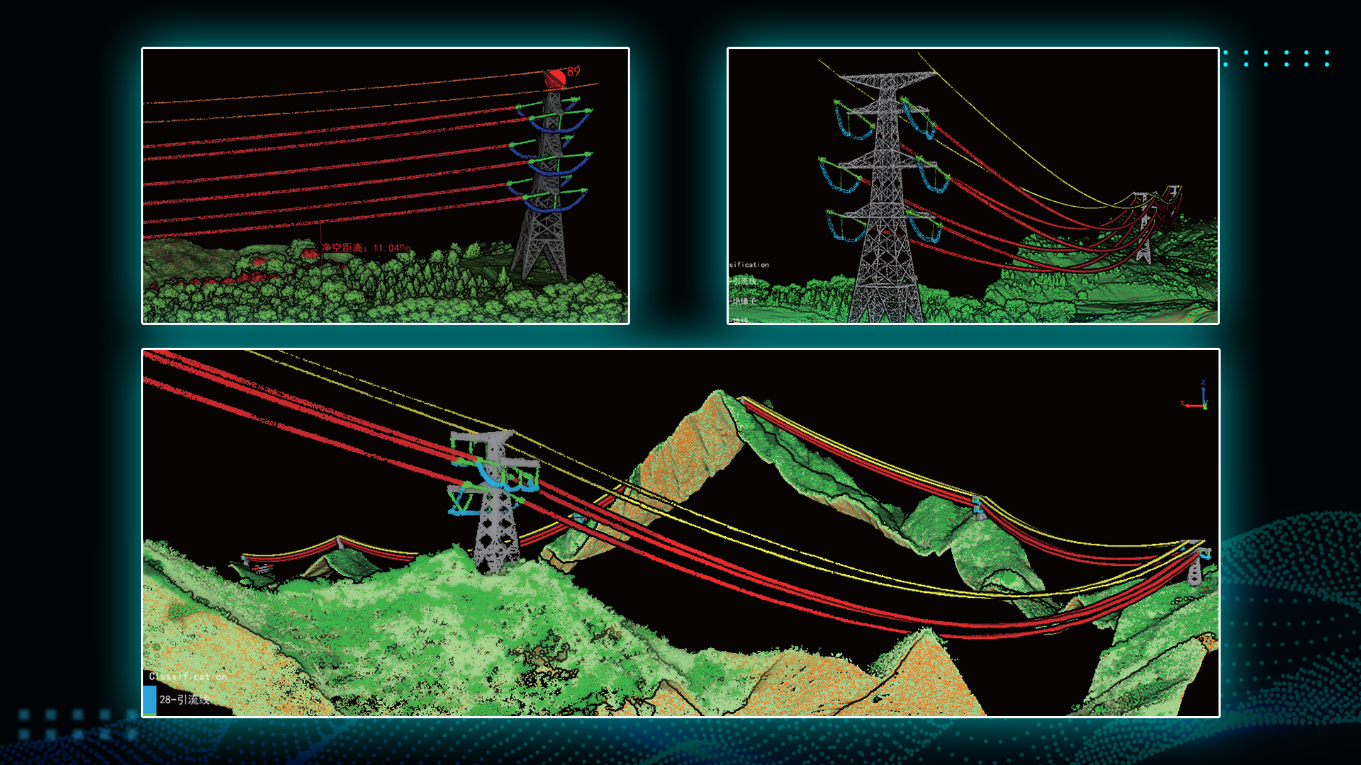
TitleInspection and analysis of power lines
LiDAR360 enables the automatic classification of point clouds of power lines and pylons, real-time analysis of the condition of power lines and the creation of a sample library of classification algorithms for machine learning. Topography, geomorphology and geological conditions within the high-voltage corridor can thus be accurately and effectively reproduced.
The LiDAR360 software enables uniform data management and analysis of line crossings, obstacles and geological conditions within the line corridor in accordance with the relevant regulations for the operation of lines. This allows power grids to be fully visualized in 3D.
Thanks to the automated processes and precise data analysis, potential hazards such as overgrown vegetation or structural weaknesses can be identified and rectified in real time. This helps to increase operational safety and reduce downtimes in the power grid. With these comprehensive functions, LiDAR360 enables optimized monitoring and maintenance of high-voltage lines, improves operational efficiency and contributes to the safety and reliability of the power supply.
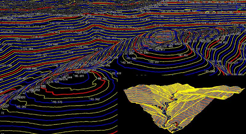
TitleGeological analysis
LiDAR360, a specialized software for processing LiDAR data, offers advanced features for precise extraction of ground points from LiDAR point clouds. By applying advanced algorithms, LiDAR360 can effectively filter the vegetation and identify the underlying ground points. This accurate extraction is crucial for the creation of reliable terrain models that serve as a basis for various analyses, for example for disaster prevention or mining investigations.
With LiDAR360, important parameters such as terrain inclination and slope direction can be accurately determined. These parameters are particularly useful for cross-section analyses and monitoring terrain changes. By analyzing slope data, for example, areas with an increased risk of erosion can be identified or potential landslides predicted.
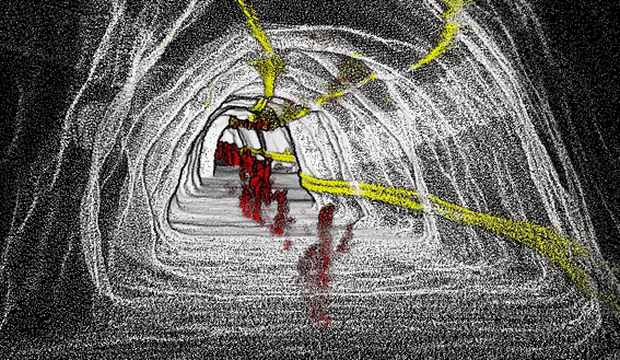
TitleMine surveying
Extraction of slope lines
LiDAR360 enables the precise extraction of slope lines, which are crucial for the stability analysis of pit walls and slopes. This helps engineers to identify potential instabilities and take safety measures.
Measurement of stockpile volume
The software accurately calculates the volume of ore, overburden and material stockpiles. This data is essential for inventory management and material movement planning and enables efficient resource utilization.
Analysis of changes in opencast mining
LiDAR360 analyzes changes in opencast mining over different time periods using 3D models. This helps to track mining progress and geotechnical shifts and to plan future mining phases.
Modeling of routes and analysis of sections
The software supports the modeling of transport routes and the analysis of cross-sections, which improves the efficiency and safety of material transport. Bottlenecks and problem areas can thus be identified.
Classification of point clouds
Point clouds can be automatically classified in LiDAR360 to distinguish different elements in the mining area. This makes it easier to monitor and manage the entire mining process, from material relocation to environmental monitoring.
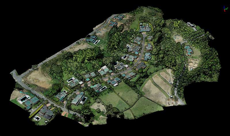
TitleReal 3D scenes
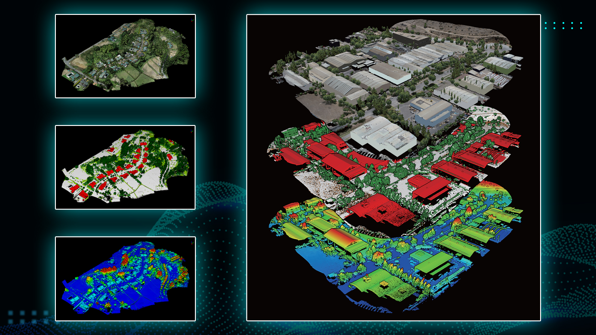
Precise segmentation and modeling of vegetation and buildings
LiDAR360 offers functions for segmenting and modeling vegetation and buildings in particular. This means that the software is able to isolate individual trees, groups of trees and buildings and create detailed 3D models of these objects.
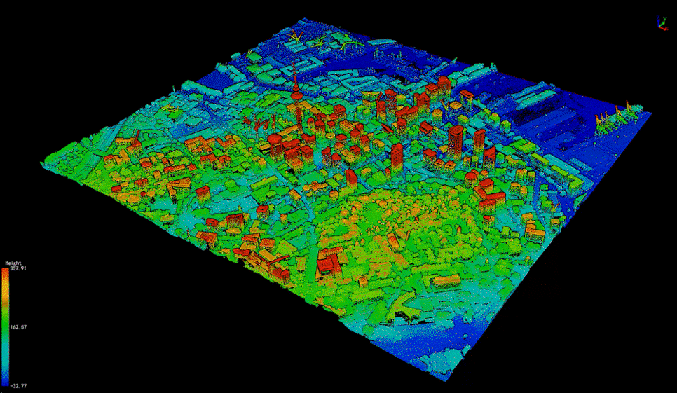
Restoration of geographical scenes
LiDAR360 enables the reconstruction of complex geographical scenes and physical replicas at city level. These reconstructions are extremely valuable for a variety of applications in urban planning, environmental monitoring and disaster management.
Supporting 3D design in construction and infrastructure projects
The models and analyses created by LiDAR360 support 3D construction in the real world. This includes construction projects where builders and civil engineers use accurate data and models to plan and monitor the progress of building projects. It also includes infrastructure development, where detailed models help with the planning and maintenance of roads, bridges and utility lines. In addition, realistic 3D models can be used in virtual environments to carry out simulations and training.
Better advice for users
Are you interested in our offer or would you like to find out more about LiDAR360? Then give us a call today and arrange a free, non-binding consultation. We will answer all your questions. As both a dealer and a user, we are ideally positioned to support you after your purchase.