Scantra

TitleScantra
Scantra is a pioneering software for geodetic registration of laser scan point clouds based on precise matching of identical surfaces and points. Designed to handle enormous projects with hundreds to thousands of scans, Scantra offers remarkable accuracy that exceeds even the error limits of traditional ICP-based solutions.
This powerful software is used in various areas such as as-built documentation, construction progress monitoring and deformation analysis. Scantra is unique on the market as it provides comprehensive and informative quality data, which is of crucial importance for engineering geodesy.
At the heart of Scantra is a high-performance block adjustment, which makes it possible to achieve reliable and precise results. The software is able to process highly redundant registrations from loop closures or stable capture configurations, further confirming its reliability.
TitleScantra - Solution for many professions
With Scantra, engineers and geodesists have access to a powerful solution that meets their high demands and provides them with the tools they need to successfully complete complex projects.
In the video on the side, Fabian Wegner from Laserscanning Europe demonstrates the basic processes of the Scantra point cloud software. From import to export, we introduce you to the Scantra workflow and discuss the major advantages of the point cloud software.
TitleBe a part of the net of Scantra
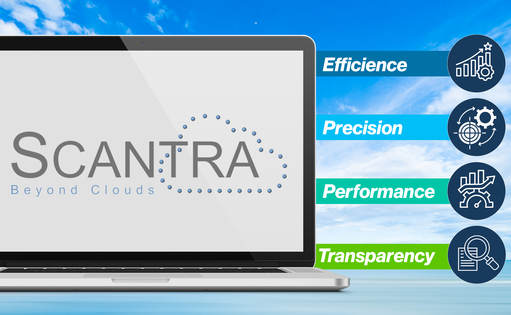
Efficiency – is achieved by reducing the number of targets required, resulting in reduced time spent in the field.
Precision – is improved by using layers instead of individual points, which optimizes the error budget.
Performance – is guaranteed by the ability to process thousands of scans on standard hardware.
Transparency – is ensured through meaningful reports that are based on block adjustment and provide proof of quality.
TitleAdvantages of Scantra
Efficiency
The Scantra algorithm focuses on redundantly captured areas in point clouds and therefore does not require targets such as checkerboard targets or reference spheres. This method significantly reduces the time required for surveying in the field, as there is no need to attach and survey targets. Nevertheless, Scantra is able to process targets, for example to reference a registered point cloud in a higher-level coordinate system.
Furthermore, Scantra offers a highly efficient algorithm based on mathematical statistics when processing large projects. This algorithm enables the localization of outliers, which is extremely time-consuming, especially when resolving contradictions in the data material.
Precision
Scantra differs from point-based approaches such as the “Iterative Closest Point” algorithm (ICP) in that the software forms correspondences between planes. This innovative approach significantly reduces the effects that can arise from the uneven distribution of points in object space. In addition, the error budget is significantly improved, as balanced planes are more precise than individual points.
Performance
Data management in Scantra enables the processing of thousands of scans. The data volume is significantly reduced by using layer parameters instead of individual points. For example, a project with 368 scans requires 19.86GB for the scan files, while the Scantra database only requires 265MB. Thanks to this lossless parameter reduction, very large projects can be processed without any problems, even with standard hardware.
Transparency
An informative proof of quality is important for both the service provider and its client. A Scantra project includes a block adjustment that takes into account the information from all stations and leads to an optimal solution, regardless of the processing sequence. Scantra uses established and transparent quality measures based on the theory of geodetic adjustment calculation.
TitleThe Scantra workflow
- Import of point clouds
- Automatic detection of planes in each scan
- Definition of scan pairs and pair registration based on:
> Automatic plane alignment
> Manual pre-alignment followed by automatic plane alignment if required - Block alignment of all scans into a common target coordinate system, based on:
> A master scan
> Coordinate-controlled target points
> Reference frame with fixed stations
Optionally, an algorithm can be started to detect outliers - Application of the adjusted transformation parameters to all scans
TitleScantra functions
What functions does Scantra offer for file import/export, registration and quality assurance?
File import
- Binary formats: E57 (universal), zfs (Zoller + Fröhlich), fls (Faro), lps (LupoScan), pcp (PointCab)
- Ascii formats: pts (Leica), xyz (Free definable)
File export
- File formats: E57 (universal) or ascii format
- Registration parameters in file header: E57 (universal), zfs (Zoller + Fröhlich), lps (LupoScan), lsdx (PointCab)
Registration
- Layer-based
- Target mark based
- Plane and target marker based
- Block adjustment (planes and / or targets)
- Image-based pre-registration (planes and / or points)
- Use of pre-orientation (requires direct georeferencing or similar)
Quality assurance
- Pairwise registration: Residuals, redundancy components and normalized improvements between points and/or planes
- Pairwise registration: Graphical representation of the planes used
- Pairwise registration: Horizontal section
- Block adjustment: Equalized registration parameters of the locations including standard deviations
- Block adjustment: Residuals and redundancy percentage for observation groups and individual observations
TitleLast Scantra updates

TitleHardware compatibility of Scantra
To get the most out of Scantra, it is essential that your computer meets the requirements of the software. Please check the hardware components listed below to ensure that Scantra runs smoothly on your system.
TitleSystem requirements for Scantra
Computer
- At least PC Pentium IV processor, at least 8GB RAM
Operating systems
- Windows 10 and higher
Network systems
- Windows Server 2003 and higher

TitleCompatible formats in Scantra
Scantra allows you to import, process and export many different types of project data and point cloud data.
TitleCompatible formats
Import of project files with or without pre-orientation:
- PointCab project
- Z+F project
- RiSCAN project
Import of scans:
- *.e57
- *.fls
- *.zfs
- *.lps
- *.ptx
- *.las
- *.laz
- *.rsp
- *.rdbx
Export of point clouds:
- *.e57
- ASCII
Export of registration parameters:
- *.zfs
- *.e57
- *.lsdx
- *.lsproj
- *.lps
- ASCII

TitleFields of application
Scantra is used wherever maximum reliability and precision are required.
Suitable analysis parameters allow registrations to be meaningfully analyzed and interpreted. The speed of Scantra registration is particularly noticeable in very large scan projects <1000 scans. By dividing the scans into layers, computer resources are conserved, but the registration processes are accelerated.
TitleIn which industries is Scantra used?
Industries in which the Scantra is frequently used include
- Surveying
- Architecture
- Engineering
- Construction
- Facility management
- Heritage
Better advice for users
Are you interested in our offer or would you like to find out more about Scantra software? Then give us a call today and arrange a free, non-binding consultation. We will answer all your questions. As both a dealer and a user, we are ideally positioned to support you after your purchase.