TopoDOT
TitleDigital Twins
TopoDOT is the ideal software for managing point cloud data from infrastructure, analyzing data quality and generating topographies, models, analyses and more as digital twins. The point cloud software processes geospatial data from roads, railways, utilities and surveys that require specialized processing. TopoDOT's production process balances automation and quality to meet complex project requirements.
Workflows are optimized by hundreds of efficient TopoDOT tools running on a powerful CAD engine. This allows you to create 3D models with the highest accuracy requirements or extract topographic outlines from scan data.
TitleExamples of applications
Topography, extraction of GIS assets and structural models
TopoDOT provides tools to extract topographic features such as breaklines, road surfaces and bare earth. It can also identify and extract GIS assets such as signs, poles and other features along transportation corridors. The software can also create detailed 3D models of buildings, bridges and other structures. It provides tools for extracting building footprints, complex support structures and bridge models from LiDAR data.
Automated analysis
TopoDOT performs automated analysis, such as extracting clearance profiles, analyzing speed recommendations, detecting collisions, assessing grades and slopes, monitoring walls, analyzing pavement conditions and ADA compliance for ramps. These features help assess and report on various infrastructure and environmental conditions.
Corridor mapping and overlap analysis
TopoDOT allows you to map and analyze corridor overlaps to ensure that transportation and utility corridors are free of obstructions and comply with spatial regulations, especially in the area of rail network monitoring and analysis.
Assessing the condition of roads and sidewalks
The point cloud software assesses the condition of roads and sidewalks and identifies problems such as pavement damage, holes and edge steps. This is crucial for maintenance and safety purposes.
TitleSystem requirements
Minimum requirements
- Processor: Core 2 Duo 2.26 GHz
- RAM: 4GB
- Graphics memory: 512MB
- Operating system: Windows 7, 64 bit
- Hard disk: 500GB 5400 RPM
Medium requirements
- Processor: Intel Core i5 6th generation
- RAM: 8GB DDR4
- Graphics card: 1+ GB, NVIDIA GeForce GTX 960
- Operating system: Windows 7, 64 bit
- Hard disk: 1TB 7200 RPM
Recommended requirements
- Processor: Intel Core i7 6700k
- RAM: 16+ GB DDR4
- Graphics card: 4+ GB, NVIDIA GeForce GTX 960 Ti
- Operating system: Windows 10, 64 bit
- Hard disk: 1+ TB Solid State Drive (SSD)
TitleSimply use point clouds from different measurement devices
TopoDOT data formats at a glance
TopoDOT can work with different types of point cloud data, such as LAS, LAZ, PTS, E57 and PLY. However, not all formats are equally efficient and compatible with TopoDOT.
The recommended format for TopoDOT is LAS, a standard format for storing and exchanging point cloud data. LAS files are compact, fast and easy to edit with TopoDOT.
You can also use LAZ files. These are compressed versions of LAS files that save disk space and bandwidth. However, you should not use PTS, E57 and PLY files, as these are slower, larger and more error-prone in TopoDOT.
Organize data perfectly with TopoDOT
Point cloud data can be very large and complex, especially when multiple scans or data sources are available. To make work easier and faster, the data should be organized into manageable segments that correspond to the logical units of each project.
For example, you can segment the data according to road sections, bridges, buildings or other features. TopoDOT's tools allow you to split, merge, cut or filter data segments. Organizing data into segments can also improve performance, accuracy and quality control.
Be on the safe side with TopoDOT
One of the most important steps when using TopoDOT is to validate and verify the results obtained. It is important to ensure that data processing, analysis and extraction are accurate, consistent and reliable.
TopoDOT's tools allow you to perform quality control, error detection and data validation. You can also compare the results to other data sources, such as aerial imagery, ground truth or design specifications. By validating and verifying the results, you can ensure that the data meets the standards and requirements of the project.
TitleInfrastructure Next Level
TopoDOT provides complete point cloud processing solutions at the lowest possible cost, increasing productivity and profitability.
With TopoDOT, you get a unique, quality-controlled process for delivering topographic and 3D structure models, GIS asset data and other digital infrastructure data.
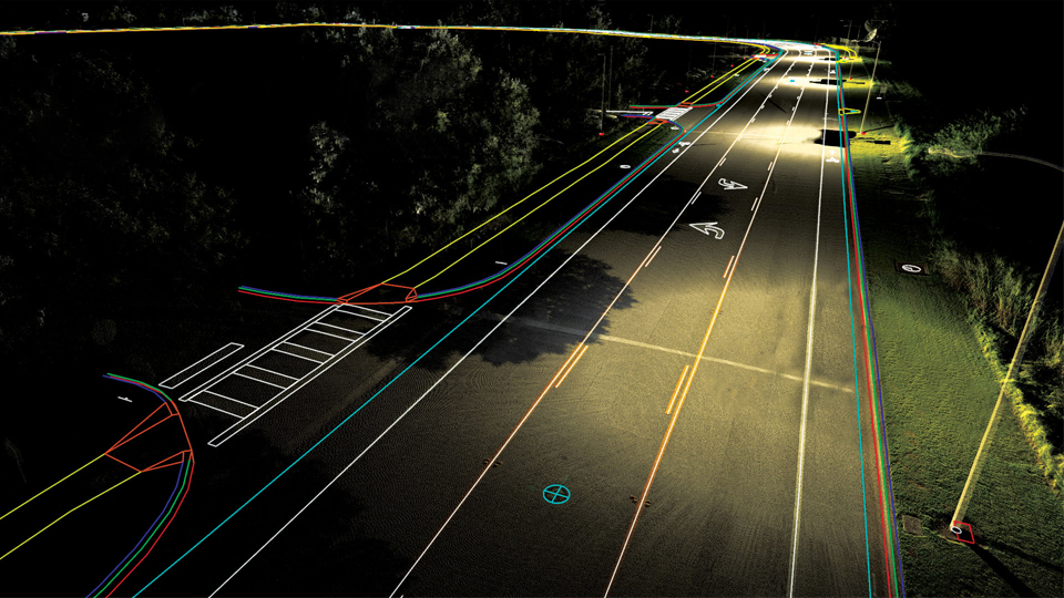
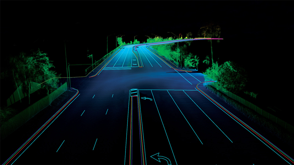
TitleAnalyzing streets in detail
Geospatial data collected along roadways has unique characteristics that can make the creation of topographies, models, analysis and other forms of digital twins a challenge.
Watch the video examples below to see how TopoDOT overcomes this challenge with a unique approach. For example, color markings and breaklines can be extracted. The software focuses on automation, productivity and quality.
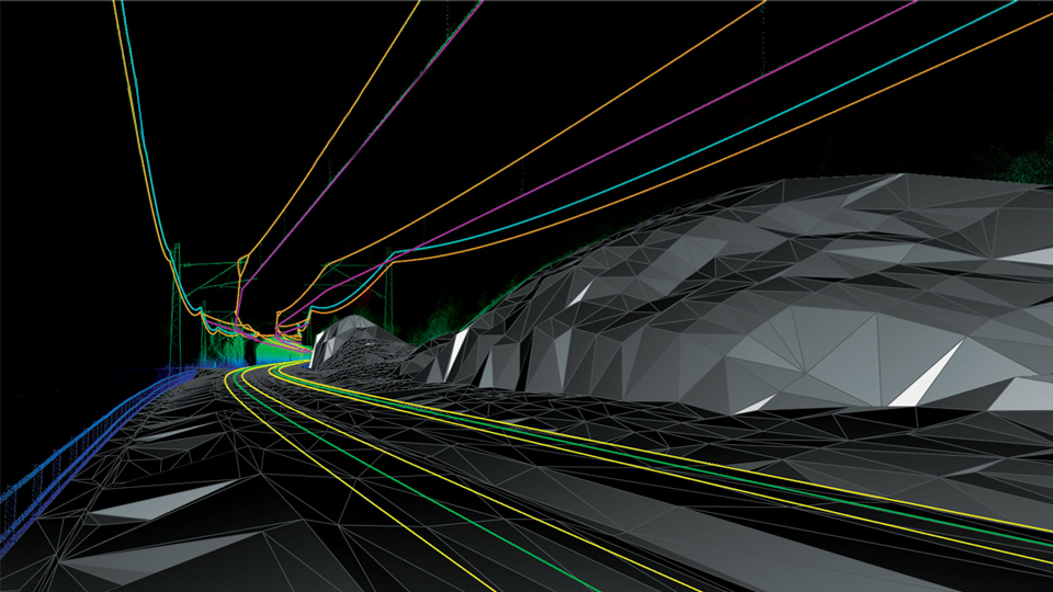
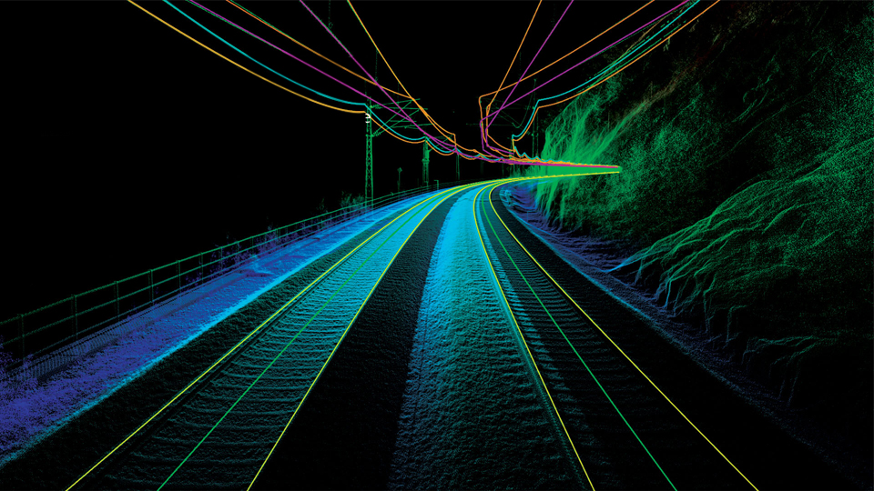
TitleExtract features from rails
TopoDOT contains highly automated tools for extracting rail-specific features such as rails, the track bed or overhead lines. The unique processes ensure that rail features are extracted with the highest possible accuracy. The software allows you to automatically check and document the quality of the digital twins.
TitleModeling of buildings
The combination of TopoDOT and a sophisticated CAD platform provides a powerful solution for extracting complex 3D models (e.g. buildings, bridges, tunnels) from geospatial data. The synergy between TopoDOT's extensive tool suite and the existing 3D CAD modeling capabilities offers limitless possibilities for creating digital twins.
TitleUse GIS data efficiently in TopoDOT
TopoDOT uses data collected by modern geographic information systems to extract objects (e.g. power lines, utility lines, poles) to support topographic models and GIS database applications. TopoDOT's tools can be used to identify, locate and extract GIS assets in the geodata. The AI-driven tools facilitate and accelerate work processes, with quality control directly integrated into the workflow.
TitleAnalysis tools in TopoDOT
In addition to creating digital twins, TopoDOT offers an extensive selection of tools for highly automated analysis and simulation. These tools extract and document actionable information from geospatial data and/or digital twin models.
The list of analysis tools includes:
- bridge clearance,
- cable spacing,
- heights of barriers,
- planting,
- roadway damage,
- earth volume,
- monitoring of walls,
- geometry of the road surface,
- curve geometry,
- analysis of curve geometry,
- simulation of road trains,
- simulation of rail vehicles
- and much more.
TitleQuality of the highest standard
TopoDOT offers a highly automated range of tools for quickly analyzing and documenting the properties and quality of project data. Automatically determined results enable the transformation of point cloud and image data into georeference coordinates. The analysis of the data is crucial for the implementation of a quality-checked creation process of the digital twin.
TopoDOT is a powerful point cloud processing software that effectively overcomes the challenges of creating topographies, models and digital twins of roadways. It offers highly automated tools for the precise extraction of features such as color markings and breaklines. It also supports the detailed modeling of buildings and rail infrastructure. The extensive range of analysis tools ensures accurate and documented results, guaranteeing the quality of the digital twins and enabling a wide range of applications.
Better advice for users
Are you interested in our offer or would you like to find out more about TopoDOT? Then give us a call today and arrange a free, non-binding consultation. We will answer all your questions. As both a dealer and a user, we are ideally positioned to support you after your purchase.