Pointscene
TitleCustomized solutions for your projects
Pointscene is a cloud-based reality mapping solution for making data-driven decisions in ever-changing construction environments and improving a project's profitability.
The Pointscene platform takes your reality mapping implementation to the next level by eliminating common data management issues. It bundles and connects digital construction site data directly to your project software, enabling easy integration into virtually any digital workflow. The intuitive web application gives stakeholders easy access to data sets that you can use as needed.
When project stakeholders have easy access to reality mapping data in their daily work, they get a better overview of the situation in all phases and areas of the project. This makes it possible to make data-driven decisions, react to unforeseen events, monitor progress, increase productivity on site and reduce rework. This saves you time and money on the most complex and rapidly evolving projects.
Pointscene is not only suitable for large companies, but also for small teams and offers tailor-made service solutions, for example for site managers, BIM managers and surveyors in infrastructure construction.
TitlePointscene features
Automated sharing
Pointscene's web services and API can automatically transfer reality mapping data to your project's favorite CAD, BIM and GIS tools, so you can incorporate it into virtually any of your digital work processes with a simple link.
Easy access
The web application provides access to all stakeholders with a web browser so they can view, download and interact with project information at any time.
Automated data processing
Pointscene uses automated processing to convert your extensive and software-specific data into a user-friendly format without compromising quality. A cloud service automatically organizes all data by time, location, project and data type, making project information easy to find.
Essential tools
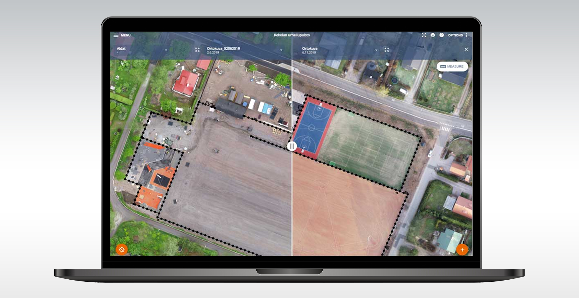
In addition to sharing and visualization, Pointscene provides tools to measure, compare and analyze your data and communicate with other parties using the maps as a reference.
TitleAdvantages for construction site management
Improved reality mapping
Pointscene enables the cost-effective digitization of buildings, facilities, construction sites and more with modern measurement methods such as drones and laser scans, so you can take full advantage of reality mapping data in your project.
Faster communication
Pointscene automatically transfers key project information between the applications used by project stakeholders, such as the client, designer, contractor and site manager, significantly speeding up communication on complex projects.
Optimized construction site management
With reality mapping data in their applications, stakeholders can better manage temporary work structures, construction materials and quantities, site logistics and much more.
Easy access to data over time
When used systematically, Pointscene provides a digital history of project progress for use during and after the construction process.
TitleDrone Maps module by Pointscene
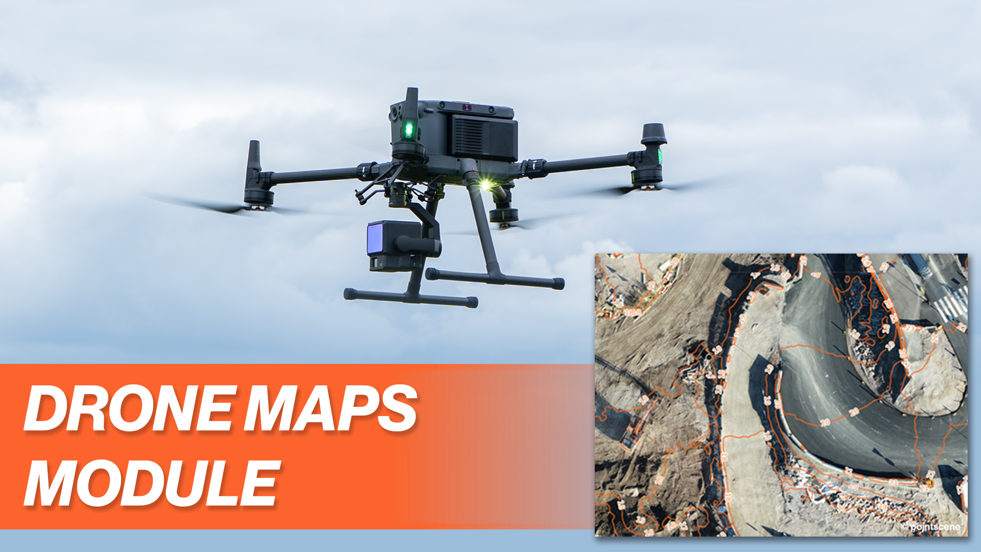
UAV mapping for construction management
Pointscene has developed a UAV mapping module for construction, BIM and surveying professionals that enables precise orthophotos and surface models. Users can upload and automatically process aerial drone photos via drag & drop. The module supports RTK drones for high accuracy, provides measurement tools and enables easy data sharing and integration into existing workflows.
TitleFor whom is Pointscene
Target user group
Pointscene is suitable for both small teams and large companies and offers precise service solutions, especially for site managers, BIM managers and surveyors in the field of infrastructure construction and BIM coordinators.
Project managers
A better awareness of the situation improves productivity on the construction site. You can also avoid mistakes that could otherwise lead to costly rework. Of course, there are always surprises, but Pointscene gives you the knowledge you need to make better-prepared decisions.
BIM coordinators
Bring the construction site to your desk. Track progress on site with UAV imagery and laser scanning data without having to visit the site regularly. Pointscene fully integrates with more than 50 of the most commonly used tools, both in the field and in the office, so you can fully monitor your construction site.
Surveyors
Share and manage your survey data. Share your drone and laser scan data with all project stakeholders in a user-friendly browser-based environment. Use the latest orthophotos as a background map in your surveying software.
Developers
Close the gap between the field and the office. Pointscene facilitates real-time communication and file sharing between all project stakeholders while keeping all information in one place. Never again will you find yourself in a situation where only one person has the key to your site data.
TitlePointscene - A cloud-based solution
The Pointscene software is a cloud-based solution developed specifically for construction, BIM and surveying professionals. No specific hardware requirements are necessary on the user side to make the best use of Pointscene, as it is a web-based application. This means that you only need a modern web browser and a stable internet connection to access Pointscene's features.
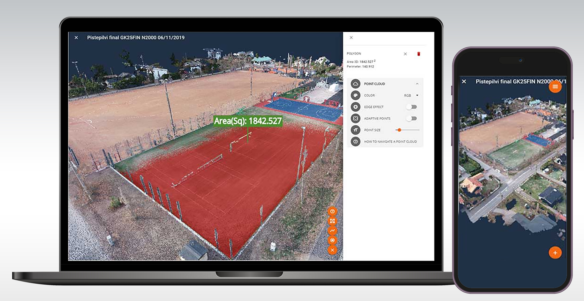
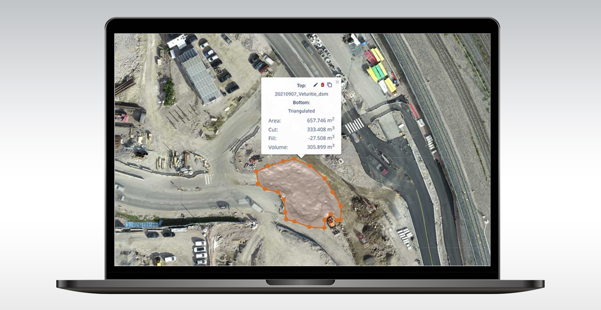
Pointscene is designed to process data from various reality capture technologies such as drone photogrammetry, 360° imagery and laser scanning and make it available in an easily accessible web interface. The software allows you to use orthophotos, point clouds and design files to calculate quantities and volumes, check height differences and document site progress (Pointscene) (Pointscene).
Pointscene also offers special data connectors for the integration and use of the data, which enable a direct connection to common construction and planning software solutions such as Autodesk Civil 3D, Trimble Connect and Infrakit.
TitleKeeping an eye on everything with reality mapping
Data compatibility
The Pointscene web application supports a range of reality mapping data types, including 3D point clouds, orthophotos, surface models, 360° images and geo-referenced images.
- Point clouds: LAS, LAZ, E57
- Orthophotos: TIF (+TFW), JP2/JPG + JGW, PNG + PGW
- Surface models: TIF (+TFW), LandXML
- Drafts: LandXML/Inframodel (surfaces), IFC 2x3
- 360° images: equirectangular projection 2:1, metadata csv file
- Images: georeferenced, e.g. with mobile phone or drone
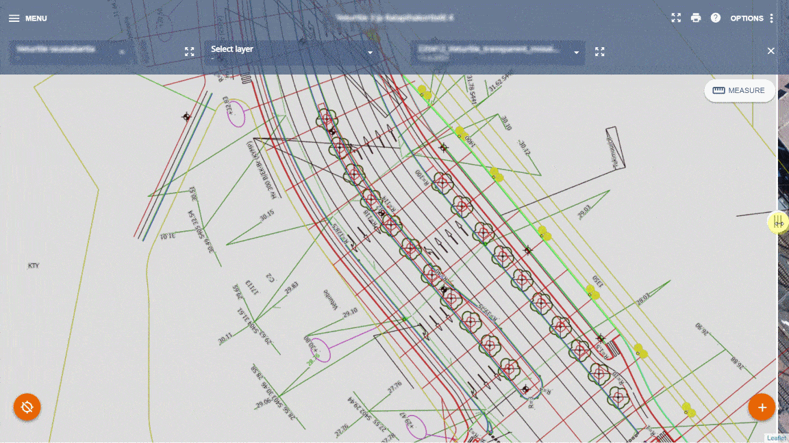
- Plans/drawings (.DWG, .DXF etc.) can be imported as raster data in 2D if they are converted to the correct format (e.g. Geotiff). Pointscene can support this requirement as an additional manual conversion service.
Browser support
The web-based application works in all modern web browsers (Chrome, Firefox, Safari, Edge) both on the desktop and on mobile devices such as smartphones or tablets.
Cloud storage
By default, all cloud data is stored and managed on the Google Cloud platform in the EU (Belgium). Further options for cloud storage or other storage locations are available on request.
Web services
Pointscene offers a variety of web services, including
- OGC Web Map Standards (WMS / WMTS / TMS / XYZ) for aerial imagery,
- Pointscene point cloud web services (potree, 3DTiles) and Pointscene.js library for 3D point cloud viewer applications,
- Pointscene API for more comprehensive data automation and custom integrations.

TitleApplication areas of Pointscene
Pointscene is a specialized software solution mainly used in the field of geospatial data management and visualization of 3D environments. The software is used by professionals in various industries to capture, process and analyze location-based data. Some of the most important areas of application for Pointscene are listed below.
Construction and engineering
- Project planning and monitoring: Pointscene is used to monitor the progress of construction projects. The software makes it possible to create up-to-date and precise 3D models of construction sites and compare them with the planned models.
- Terrain analysis: Civil engineers use Pointscene to capture and analyze detailed topographical data, which is critical to the planning and execution of construction projects.
Infrastructure and utilities
- Network analysis: Utilities use the software to collect and analyze data about their infrastructure, including power lines, water and wastewater systems.
- Maintenance and inspection: Pointscene helps to plan and carry out inspection and maintenance work by providing accurate and up-to-date 3D data.
Urban planning and development
- Visualization and simulation: Urban planners use Pointscene to create 3D models of urban areas and simulate various development scenarios.
- Asset mapping: The software is used to collect and manage data on existing urban infrastructures.
Forest management & environmental protection
- Monitoring the environment: Pointscene is used to collect and analyze environmental data, which is helpful in monitoring environmental impacts and planning conservation measures.
- Forestry: Foresters use the software to map forest areas and analyze forest resources.
Disaster management and emergency relief
- Emergency planning: Pointscene helps to create emergency plans by providing accurate 3D data of potential hazard areas.
- Reconstruction: After natural disasters, the software can be used to assess the damage and plan for reconstruction.
Mining
- Exploration and mining: Pointscene is used in the mining industry to collect and analyze data on mine sites and operations.
- Safety monitoring: The software helps monitor the safety of mines by providing up-to-date and detailed 3D models.
Better advice for users
Are you interested in our offer or would you like to find out more about Pointscene software? Then give us a call today and arrange a free, non-binding consultation. We will answer all your questions. As both a dealer and a user, we are ideally positioned to support you after your purchase.