Proceq GS8000
TitleThe GS8000 (Pro) GPR sets new standards
The Subsurface GPR (Ground Penetrating Radar) with SFCW (Stepped-Frequency Continuous Wave) technology is a GPR system for detecting and mapping the subsurface at the highest resolution. With the help of the Proceq GS8000, you can detect metallic and non-metallic pipes and other objects underground. The ground is not destroyed during detection.
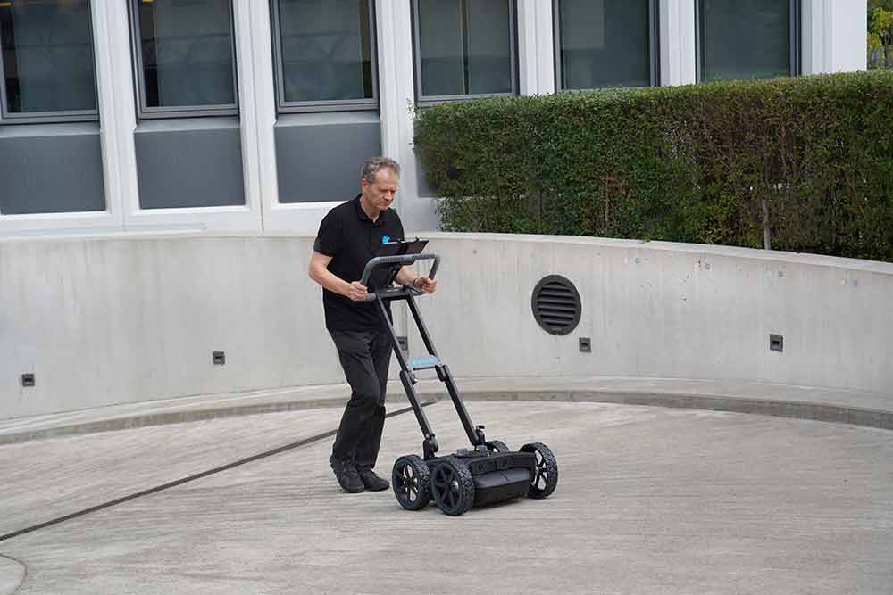
The GS8000 is a trolley for pushing and pulling. The GPR is located on the underside of the trolley; the GNSS antenna is mounted above it, and an iPad Pro is attached to the push handle for live detection and operation.
TitleHigh-precision positioning
Thanks to Plug&Play GNSS integration, the system has highly accurate positioning technology, including access to the position correction data service.
All GNSS satellites are supported.
The Europe-wide SSR extension offers real-time accuracy of 1 – 5 cm within seconds.
TitleResolution & depth combined in one GPR
The GPR of the Proceq GS8000 is optimized to detect even small and closely spaced objects, even at great depths.
The SFCW technology covers a remarkable bandwidth of 40 – 3440 MHz!
This means that even objects just 1 cm in size can be detected at depths of up to 8 m.
TitleOptimum handling and user-friendliness
The GS8000 ground radar can be controlled via the iPad Pro using familiar touch technology. The app is always up to date. This creates effortless end-to-end workflows on site and, thanks to multiple on-site visualizations, detection can be tracked in real time.
The obligatory GS app is cloud-based and provides direct 1D, 2D and 3D on-site views, including AR & AI support.
The results can also be converted into common CAD and GIS formats at the touch of a button and much more!
TitleVersatile & comfortable
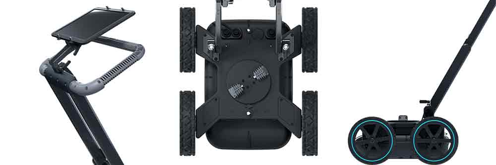
The GPR GS8000 is the ideal companion for indoor and outdoor work. The system adapts effortlessly to all ground conditions, is compact and cordless. Thanks to its ergonomic adjustment options, it enables fatigue-free working throughout the day, even on larger projects and long periods of operation.
The push/pull trolley has an adjustable ground clearance of 0 – 25 mm, so the height of the GPR can be adjusted to suit the ground conditions.
With its compact dimensions of 610x570x380 mm and a weight of < 25 kg, the GPR GS8000 is a flexible partner for your project. Thanks to its powerful rechargeable batteries and power bank, there are no limits to the system.
TitleProceq GS8000 to the point
Modular frequency range: 40 – 3440 MHz
Effective bandwidth: 3200 MHz
Weight: < 25kg
Scan speed: Up to 100 scans per meter
Push/pull speed: Max. 80 km/h (assuming mounting on suitable system)
Dimensions: 610x570x380mm
Penetration depth: Up to 10m (depending on ground conditions)

TitleApplications of GS8000 (Pro)
Frequent areas of application are:
- Localization of pipelines & cables
- Surveying with 3D laser scanning and GPR
- Non-destructive testing
- Road & bridge construction
- Police & public safety authorities
- Archaeology
- Geotechnics
- Environment, agriculture & forestry
TitleFields of application for GS8000 (Pro) GPR
Non-destructive investigation of the concrete structure
With the GS8000, you can examine the subsurface non-destructively down to a depth of several meters. Identify and document precisely:
- Cables
- Tension cables
- Reinforcing steel/wire
- Cracks & cavities
- Honeycomb formation
- Delamination
Environment, agriculture & forestry
Use the GPR to:
- Mapping the water content in soil
- Delineation of drainage systems
- Mapping tree roots
- Measuring moisture in wood products
- Mapping underground storage tanks
- Investigation of groundwater conditions
- Determination of pollutants
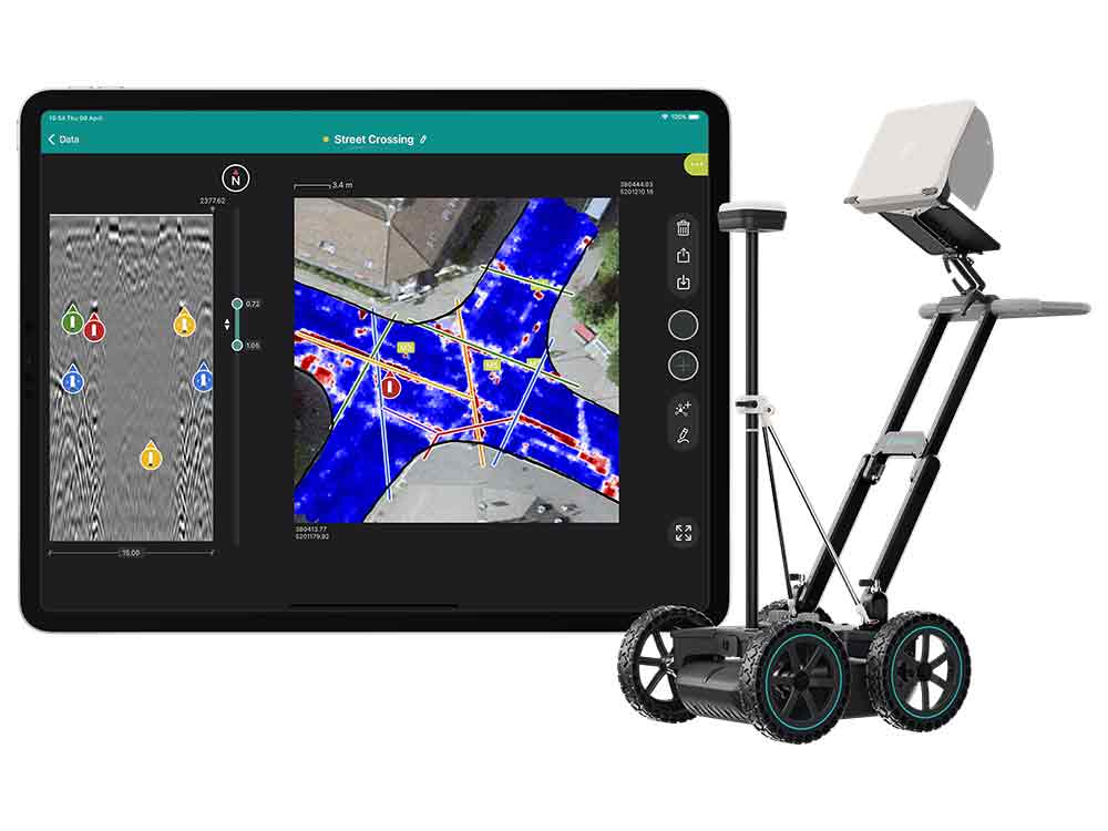
Comprehensive surveying with laser scanning & GPR
Capture buildings or industrial facilities digitally with a laser scanner and supplement your data with information on the subsurface provided by the GS8000 ground penetrating radar. This allows you to create a complete model that integrates both above-ground and underground data.
Interesting for:
- Underground supply engineering
- Construction surveying
- Industrial plants
- Creation of complex maps
Efficient maintenance in road & bridge construction
Use GPR technology to measure the layer thickness of road surfaces and the structure of carriageways and bridge decks. Plan modernization measures efficiently and precisely.
Support for police & safety authorities
The GS8000 provides crime scene investigators and forensic experts with reliable results. It helps to detect:
- Buried bodies
- Weapons & drug caches
- Stolen property in walls & floors
- UXO
TitleReliable localization of pipes & cables
Locate and map metal, plastic and concrete pipes precisely and in real time. With the Proceq GS8000 GPR, you get detailed and instantly available image data that enables network engineers to create accurate reports for underground utilities.
Ideal for:
- Gas networks
- Electricity utilities
- Water management
- IT & TV technology companies
TitleGeotechnics
GPR technology is ideal for near-surface geophysical or structural investigations. Check the condition of structures through regular inspections and create complex maps with advanced software solutions.
Applications:
- Detection of collapses & subsidence
- Measurement of rock depth
- Soil stratigraphy
- Determination of the groundwater level
- Bathymetry
- Road construction
TitleArcheology
Track down cultural treasures with ground penetrating radar.
Detect foundations of historic buildings, roads, tunnels and wall structures.
Facilitate the search for unmarked graves and the mapping of historic cemeteries.
TitleGS8000 - Easy to set up & quickly ready for use
The system can be easily pushed and pulled in the desired direction using the ergonomically adjustable handle on the trolley. The GNSS receiver provides precise positioning data. The GPR is located on the underside of the trolley. The GPR GS8000 detects both metallic and non-metallic objects in the ground.
The system adapts easily to all ground conditions. You can also choose whether the GPR rests directly on the ground or is positioned at a height of 25mm in difficult ground conditions.
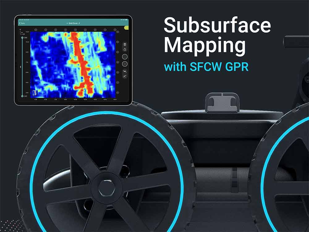
TitleCollect data efficiently
The information recorded by the SFCW (Stepped Frequency Continuous Wave) technology is visualized live on the tablet display. The measurement data provides information on the position, depth and location of underground objects (e.g. pipes) so that you can analyze the subsurface on site. On the iPad, you can switch between different views and resolutions during data acquisition, add comments and voice messages, for example, and mark the type of pipe (e.g. gas, electricity, waste water).
The major advantage of the stepped frequency continuous wave technology used is the stepless and gapless recording of the depth compared to a regular GPR, which works with the pulse method.
The SFCW-GPR, which covers a frequency range of 40 – 3.440 MHz, provides high-resolution data and is particularly suitable for
- small objects
- closely spaced objects
- deeper objects
TitleVarious options for visualizations & reports
TitleTechnical specifications of GS8000 (Pro)
| Technical data | GS8000 (Pro) |
|---|---|
| Radar technology | Stepped-frequency Continuous-Wave GPR |
| Modulated frequency range | 40 – 3440 MHz |
| Effective bandwidth | 3200 MHz |
| Min. detectable target size | 1cm |
| Max. penetration depth | 10m |
| Scan rate | 500 Hz |
| Spatial interval | Up to 100 scans/m |
| Acquisition speed | Up to 80 km/h |
| GNSS receiver | Multiband GPS + Glonass + Galileo + Beidou SSR augmentation / NRTK-compatible ⁴ Dimensions: 145 x 145 x 70 mm Weight: 0.7 Kg, 4x AA-batteries included |
| GNSS real-time 3D accuracy | Typ. 1 – 5cm |
| GNSS initialization time | Typ. 5 – 30 s |
| Wheel encoders | 2 |
| Configurations | Proceq GS8000 Proceq GS8000 Pro |
| Weight | 24kg |
| Dimensions | 61x57x38cm |
| Antenna positions | Ground-coupled with dual-axis floating Air-coupled with 25mm clearance |
| Ingress protection (IP) / sealing | IP65 |
| Power supply | Removable flight-safe battery pack | Off-the-shelf power bank |
| Autonomy | 3.5 hours | Full working day |
| Operating temperature | -10° to 50°C |
| Operating humidity | <95% RH, non-condensing |
| Connectivity | WiFi, Ethernet, USB-A, USB-B, USB-C, Lemo |
TitleTechnical specifications of Proceq GPR Subsurface App
| Technical data | Proceq GPR Subsurface App |
|---|---|
| Measurements modes | Line Scan Grid Scan Free Path |
| Visualization modes | A-scan Line Scan Line Scan migrated Time Slice View Map View Augmented Reality |
| On-site annotations | Tags Markers Photos Points of interest Voice notes Markups Linework |
| Display settings | Slice depth and thickness Auto / linear / time gain Background removal Multi-layer dielectric constant Time window Noise cancellation filter Frequency filter Low pass filter Color palette Object layers |
| Reporting | Workspace integration Automatic logbook Instant map / drawing generation Instant report generation Share via url |
| Export formats | SEG-Y DXF SHP KML HTML |
| Coordinate System | EPSG global database Local grid models Geoid models |
| Languages | English Spanish French German Italian Chinese |
| Display unit | Any iPad® or iPad Pro® ¹ Recommended: iPad Pro WiFi + Cellular Screen resolution: up to 2732 x 2048 pixels Storage capacity: up to 1 TB |
Better advice for users
Are you interested in our offer or would you like to find out more about Proceq GS8000? Then give us a call today and arrange a free, non-binding consultation. We will answer all your questions. As both a dealer and a user, we are ideally positioned to support you after your purchase.