XGRIDS Lixel L2 Pro

TitleLixel L2 Pro - Compact & high-precision mobile laser scanner
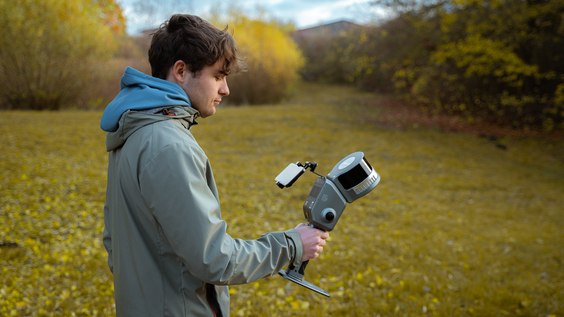
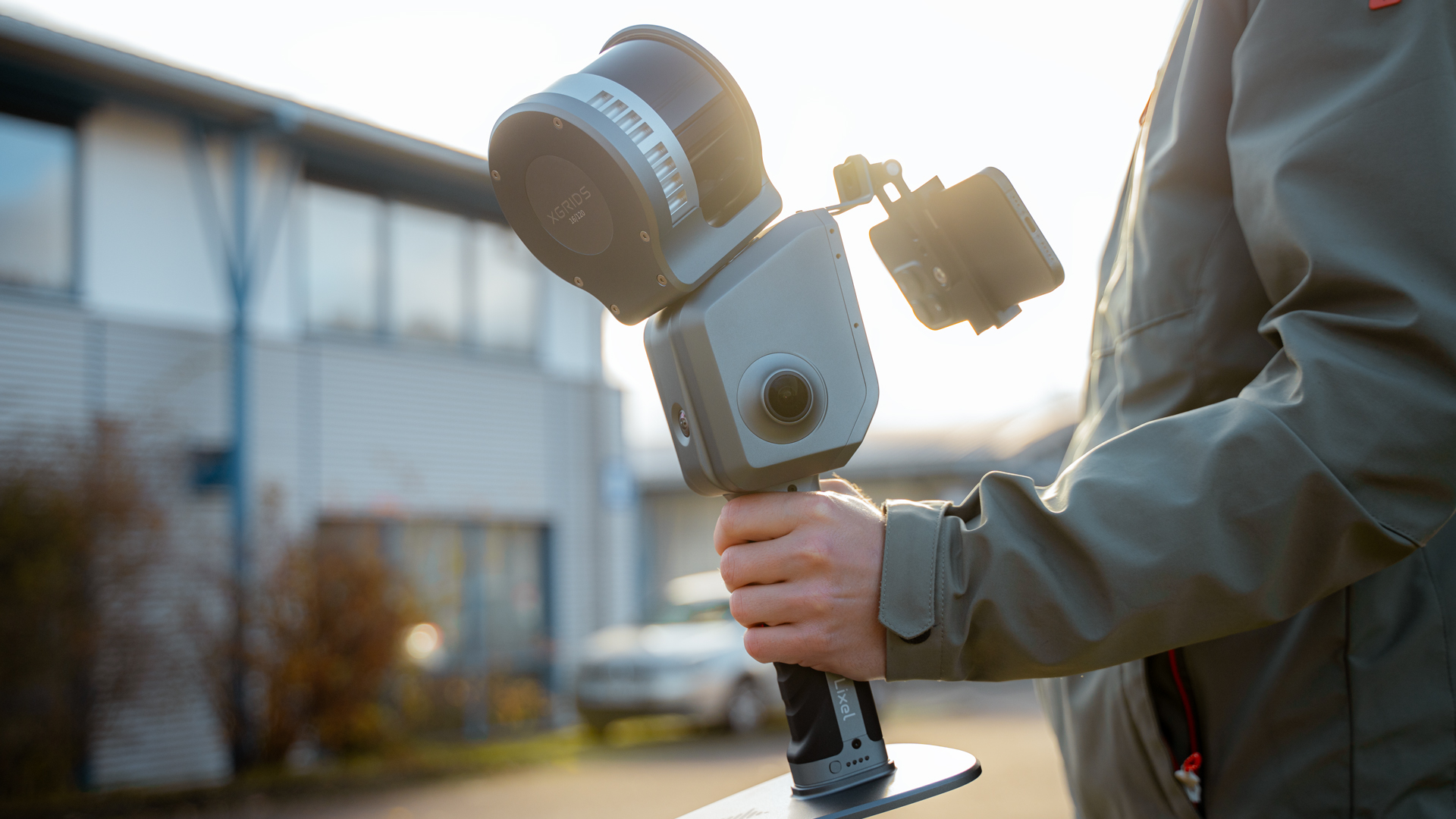
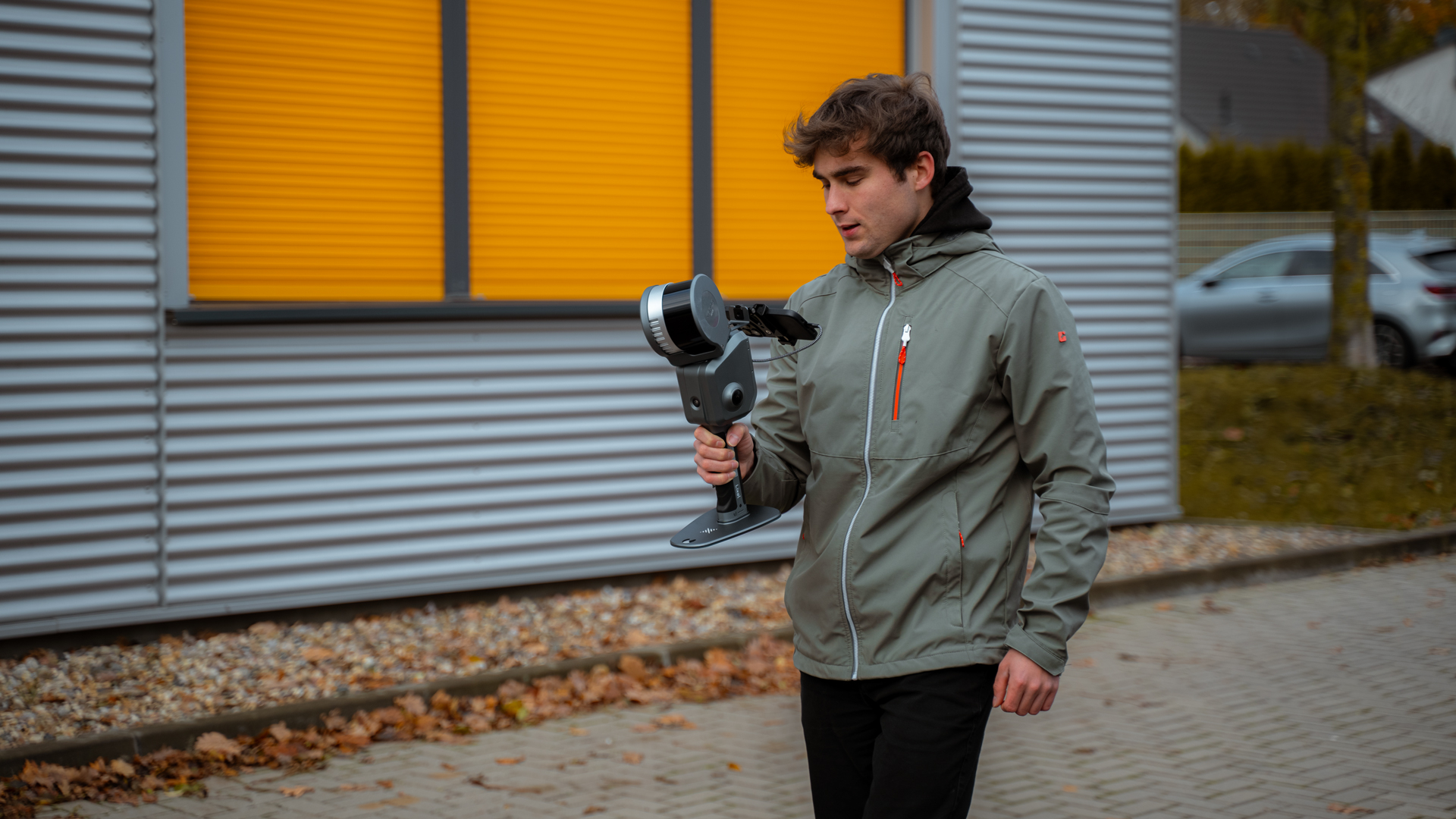
The Lixel L2 Pro from XGRIDS is a compact and highly accurate mobile laser scanner designed for versatile surveying and 3D data capture applications. It has a range of up to 300 meters and can generate precise, high-density point clouds, ideal for topographic surveys and urban 3D models.
With its lightweight design and flexible mounting options, e.g. on drones or vehicles, it offers a wide range of applications in the field. In addition, the Lixel L2 Pro is characterized by its user-friendliness and fast data processing, which makes it particularly attractive for mobile mapping and geodetic tasks.
TitleLiDAR sensor with impressive accuracy
The XGRIDS Lixel L2 Pro is a mobile LiDAR scanner with impressive accuracy and a rotating sensor head that provides real-time point cloud data.
Thanks to the integrated LiDAR, visual and IMU modules as well as the multi-SLAM optimization, precise 3D data is generated with a vertical and horizontal accuracy of 3cm and a relative accuracy of 2cm. The 6 DOF IMU ensures maximum precision during data acquisition.
The real-time coloring effects and the quality of the delivered data are in no way inferior to post-processing, so that the data is ready for immediate use.
TitleLixelUpSample™ algorithm
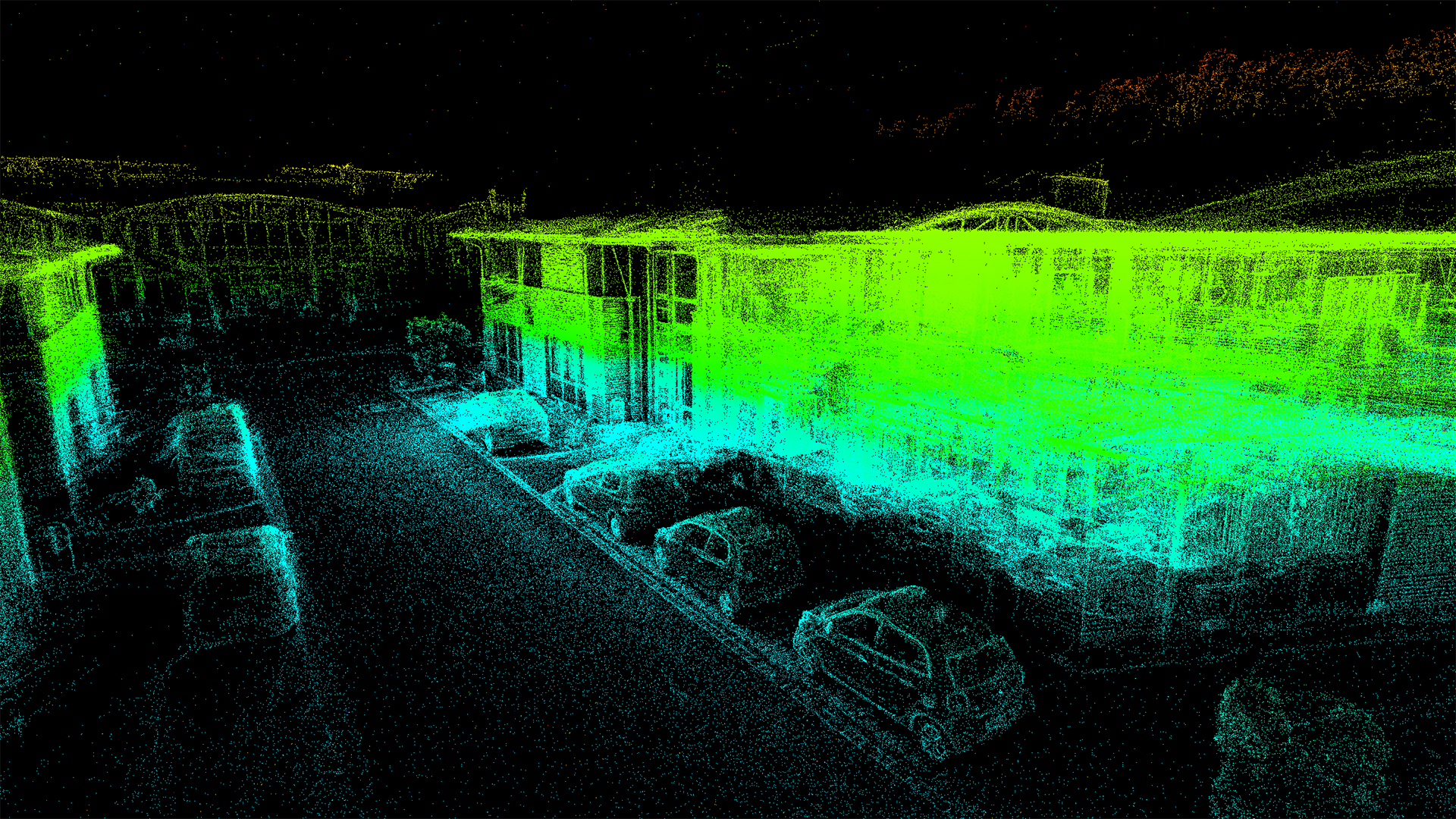
The XGRIDS Lixel L2 Pro uses the innovative LixelUpSample™ algorithm to create photo-quality color dot clouds. With a dot density of 1 million dots per square meter and a dot pitch of just 1mm, it captures even the finest details with maximum precision.
The point cloud thickness of 5mm enables particularly precise mapping and detailed line drawing.
The ultra-high coloration accuracy also ensures realistic, photorealistic color representations of the point clouds.
TitleRealistic color display

The XGRIDS Lixel L2 Pro is equipped with two powerful 48MP cameras that enable a realistic color representation of the point clouds. The cameras capture colors with an impressive level of detail and a wide field of view of 190° x 190°. This results in high-quality colour point clouds that provide a true-to-life visualization of the scanned environment.
The combination of precise LiDAR data and high-resolution color information makes the Lixel L2 Pro a first-class tool for 3D mapping.
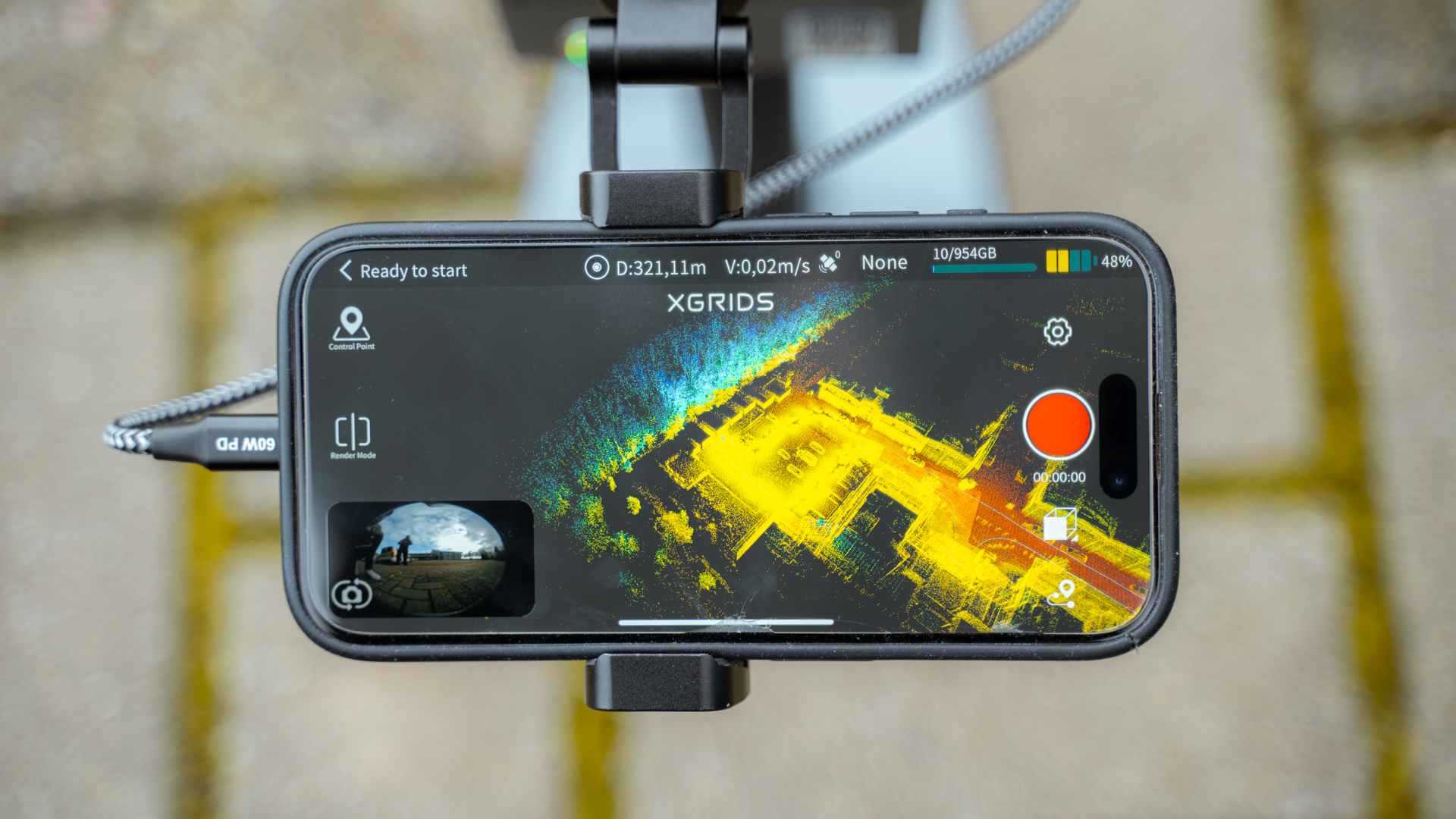
TitleLixel Go App
With the Lixel Go app, you can conveniently control the Lixel L2 Pro and create and manage projects directly on your Android or iPhone device.
The app offers complete process flows such as RTK setting and rescanning of control points, as well as a real-time display of camera images, elevation information and true-color point clouds.
It also displays important status information such as battery level, network connection, memory and range to ensure seamless data capture.
TitleLixel Studio
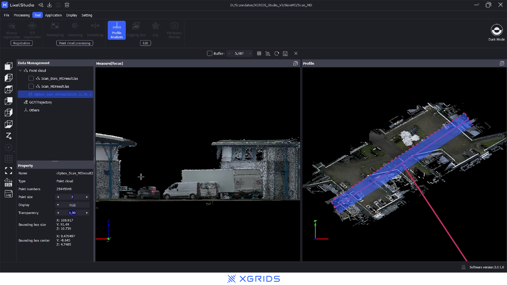
Lixel Studio is XGRIDS' software solution for processing and analyzing LiDAR data captured with the Lixel L2 Pro.
In the software, users can visualize and edit point clouds in real time and prepare them for various applications such as mapping or 3D modelling.
Lixel Studio also offers advanced data processing functions, such as colour correction and density optimization of point clouds, as well as export options for various formats.
TitleLixel Cyber Color
The visualization with XGRIDS Gaussian Splatting in combination with the Lixel L2 Pro enables a particularly realistic and detailed visualization of point clouds.
By using the Gaussian splatting algorithm, the point clouds are smoothed and visually optimized, resulting in a higher level of detail and better depth representation. This technique provides smooth, photorealistic 3D visualizations that are ideal for complex mapping and precise 3D models.

TitlePrecise applications for every industry
The Lixel L2 Pro from XGRIDS offers an outstanding solution for various applications that require accurate and efficient 3D data capture.
With its exceptional accuracy and ability to deliver point clouds in real time, the Lixel L2 Pro is ideal for various fields of application:
TitleXGRIDS Lixel L2 Po applications
Topographic mapping
Use the Lixel L2 Pro for the precise creation of detailed topographic maps. The dense point cloud capture allows you to accurately map even complex terrain and small details to realize your mapping projects at the highest level.
Agricultural & forestry surveying
The precise surveying of agricultural land and forests is simplified with the Lixel L2 Pro. With the ability to capture large areas quickly and accurately, you get reliable data for crop planning, forest management and resource analysis.
Smart City
Capture urban environments with the highest precision for smart city initiatives. The Lixel L2 Pro delivers detailed 3D models of urban landscapes that can be used for planning infrastructure projects, traffic analysis and digital modeling of cities.
Engineering surveying
Whether you work in surveying, urban planning or engineering, the Lixel L2 Pro gives you the flexibility and precision you need for your most demanding projects. Learn more about how the Lixel L2 Pro can optimize your workflow.
TitleExperience high-precision 3D mapping in real time
The Lixel L2 Pro from XGRIDS revolutionizes mobile laser scanner technology. With its powerful LiDAR sensor and advanced multi-SLAM optimization, the L2 Pro offers the ability to capture point clouds in real time with an impressive accuracy of up to 3cm.
Thanks to the rotating LiDAR sensor head and the precise 6 DOF IMU, every movement is captured, while the innovative Lixel UpSample™ algorithm delivers extremely dense point clouds with 1 million points per square meter. Every detail is captured down to the millimeter.
TitleReal-time data - ready for immediate use
The Lixel L2 Pro enables the real-time capture of true-color point clouds that can keep up with post-processed data in terms of quality.
With the Lixel Go app, available for Android and iOS, you retain full control:
Manage projects, set control points and monitor data acquisition in real time.
Avoid false captures with live displays of camera images, elevation information and true-color point clouds directly on your mobile device.
TitlePhotorealistic color display for detailed results
Equipped with two 48 MP cameras, the Lixel L2 Pro captures realistic colour point clouds, which are optimized by the wide-angle view of 190° x 190° and the Gaussian splatting algorithm.
This produces razor-sharp 3D visualizations that are ideal for sophisticated mapping and 3D modelling.
TitleFull control and overview
In addition to precise data acquisition, the Lixel L2 Pro displays the status of the batteries, networks, memory and range in real time. This means you always have full control and can ensure that your recording is complete and error-free.
TitlePerfect for demanding applications
Whether in urban planning, construction or surveying – the Lixel L2 Pro is your indispensable tool for high-precision and fast data capture.
Optimize your workflows and experience how the Lixel L2 Pro takes your projects to the next level.
TitleSpezifikationen vom XGRIDS Lixel L2 Pro
System parameters
| Technical specifications | Values |
|---|---|
| Weight | 1.7kg |
| Dimensions | 180x130x400mm |
| Outer casing | Industrial-grade aluminum |
| Power consumption | < 30W |
| Interfaces | USB 3.1 Gen2 |
| Storage | 1 TB SSD |
| Continuous operation time | 1.5 hours |
| Wireless connection | Supports WiFi & Bluetooth |
Environment
| Technical specifications | Values |
|---|---|
| Operating temperature | -20°C ~ 50°C |
| IP rating | IP45 |
Functions
| Technical specifications | Values |
|---|---|
| Visualpositioning | Supported |
| Real-time RGB | Supported |
| Real-time RTK Fusion | Supported |
utput
| Technical specifications | Values |
|---|---|
| Point cloud formats | .las; .ply |
| Image formats | .jpg |
Real-time accuracy
| Technical specifications | Values |
|---|---|
| Absolute vertical accuracy | 3cm |
| Absolute horizontal accuracy | 3cm |
| Relative accuracy | 2cm |
Processed accuracy
| Technical specifications | Values |
|---|---|
| Absolute vertical accuracy | 3cm |
| Absolute horizontal accuracy | 3cm |
| Relative accuracy | 1 cm |
| Repeat accuracy | 2cm |
| Point cloud thickness | 5mm |
| Horizontality with RTK | 0.015° |
| Verticality | 0.03° |
| LixelUpSample | Supported |
LiDAR
| Technicalspecifications | Values |
|---|---|
| Operating range | 0,5 ~ 120m 0,5 ~ 300m |
| LiDAR sensor | Class 1 / 905nm |
| Scanning frequency | 320,000 points/s 640,000 points/s |
| Sensor FOV | 360° x 270° |
Camera for panoramic images
| Technical specifications | Values |
|---|---|
| Resolution | 2 x 48MP |
| Focal length | 2mm |
| Aperture | F/2.0 |
| CMOS | 1/2" |
| Shutter | Rolling Shutter |
| FOV | 190° x 119° |
Camera for visual positining
| Technical specifications | Values |
|---|---|
| Resolution | 1 x 1MP |
| Shutter | Global Shutter |
| FOV | 190° x 119° |
Battery
| Technical specifications | Values |
|---|---|
| Voltage | 14.4V |
| Capacity | 46.8Wh |
Charging
| Technical specifications | Values |
|---|---|
| Input | 100V ~ 240V 50 ~ 60 HZ 1.5A 80VA |
| Output | 61.8V; 2.0A |
| Power rating | 34W |
Accessories and RTK
| Technical specifications | Values |
|---|---|
| Backpack with stabilizing arm | Dimensions: 60x60x15cm Weight: 2.5kg |
| Backpack with padding | Dimensions: 55x35x25cm Weight: 2.7kg |
| Standard RTK | Supported channels: GPS L1/L2/L5 GLONASS L1/L2 BDS B1/B2/B3 Galileo E1/E5a/E5b/E6b Accuracy: Horizontal: 0.8cm + 1ppm Vertical: 1.5cm + 1ppm Antenna: Impedence: 50 ohms Polarization mode: right-handed circular Polarization: Horizontal coverage angle: 360° Output standing wave: <2.0 Maximum gain: 2.8dBi |
| Survey grade RTK | Supported channels: GPS L1/L2/L5 GLONASS L1/L2 BDS B1/B2/B3 Galileo E1/E5a/E5b/E6b Accuracy: Horizontal: 0.8cm + 1ppm Vertical: 1.5cm + 1ppm Antenna: Impedence: 50 ohms Polarization modes: right-handed circular Polarization: Antenna axis ratio: <3dB Horizontal coverage angle: 360° Output standing wave: <2.0 Maximum gain: 5.5dBi |
| 2m extension pole | Supported |
| Mobile phone mount | Supported |
| Control point plate | Supported |
| Shipping case | Dimensions: 42x34x18cm Wewight incl. system: 6.6kg |
Better advice for users
Are you interested in our offer or would you like to find out more about XGRIDS Lixel L2 Pro? Then give us a call today and arrange a free, non-binding consultation. We will answer all your questions. As both a dealer and a user, we are ideally positioned to support you after your purchase.