Modern technologies in road construction - Expansion of the Turku E18 ring road in Finland

TitleThe construction of the Turku E18 ring road in Finland
Road construction in Finland always presents surprises due to the rocky subsoil and terrain, as in the case of the Turku E18 ring road in Finland. The Finnish landscape is characterized by numerous lakes, rivers, mountains, and glaciers. Road expansion often proves to be a challenge.
For the proper construction of roads and their connection to the transport network, a precise analysis of the geographical surface is required. Only with accurate as-built documentation can project managers make reliable decisions.
How did modern technologies enable the entire Turku E18 bypass project to be completed ahead of schedule (6 months) and under budget (-10%)?
Scanning and documenting the construction site with drones
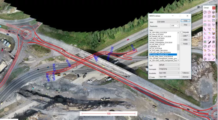
In the case of the Turku E18 ring road, drones were used to scan and record the situation on site. Orthoimages generated from drone images enabled planners, construction managers, and project management to understand the situation on site. This enabled stakeholders to monitor construction progress, increase productivity, and make decisions based on up-to-date data.
Pointscene software was used to process the data captured by the drones. Pointscene made it possible to quickly and reliably share the orthoimages with project departments and monitor construction progress. This approach resulted in a 10% cost savings and a time saving of six months compared to the original estimates.
Companies involved
In this case, the surveying and scanning was carried out by Destia, a Finnish infrastructure and construction company. It was important that daily workflows ran efficiently and everyone was aware of the current situation. Orthophoto documentation provided workers with a current overview of the construction site with weekly updates.
The project was built in two phases, with the first phase being carried out by Destia and the second phase by the construction company Kreate. Both companies used Pointscene.
Turku E18 Ring Road - Facts at a glance
The length of the road to be expanded was approximately 6 km. 12 to 14 underpasses and bridges had to be planned and taken into account on this section.
After completion of the project, the total cost was approximately 90 million euros, approximately 10% below the estimated cost.
Construction of the road section was completed on January 21, 2023.
TitleImplementation of the project
Construction site data was collected approximately once a week. The processed data was uploaded to Pointscene. Point clouds and orthophotos, organized by time and location, could be easily accessed, shared with third parties, and downloaded as needed. Data could also be compared and progress analyzed throughout the project.
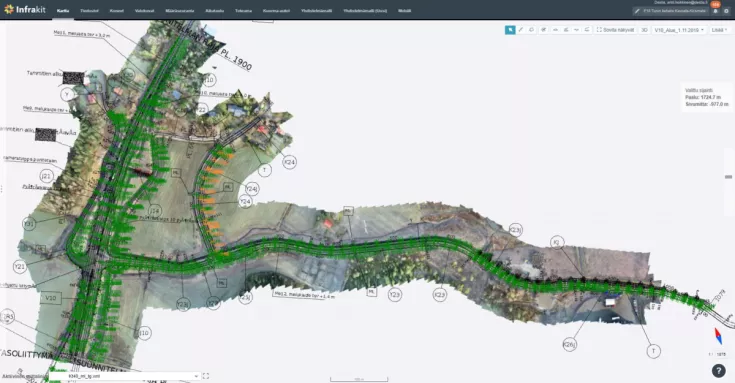
Pointscene orthophotos were transferred to Infrakit, where they were used for site planning, as meeting documents, and as orientation aids. The data was also made available to users of the 3D-Win surveying software either via the Web Map Service or as downloadable files. This was very helpful, as it eliminated the need to use external drives to share or manage project-related datasets. All data was located and secure in Pointscene.

TitleResults of the construction project
All Infrakit users on the project consistently used the orthophotos as a basis and as-built data. Using this data optimized and supported communication among project staff. Furthermore, the use of Pointscene orthophotos, Pointscene point clouds, and the exchange of data via Infrakit enabled an overview and better understanding of the current situation. The lead surveyor uses the data for as-built surveys, reporting, and work monitoring.
With the help of the Pointscene software, it is possible to quickly and reliably share the orthophotos with the project departments and monitor construction progress.
TitleConsulting in infrastructure construction
If infrastructure projects are also of interest to you, please contact us. We would be happy to advise you on solutions that will help you implement your projects more efficiently.
You can read the original article by Pointscene here: Turku E18 Ring Road: Drones became irreplaceable once they were part of the workflow.