ELIOS 3 drone used for 3D mapping of a nuclear waste repository

TitleChallenge of 3D mapping
In the 1950s, the Department of Energy contracted with the state of Idaho to store 4,400 cubic meters of nuclear waste in a secure facility, the Idaho Nuclear Technology and Engineering Center.
This waste is a highly radioactive, granular solid made from spent nuclear fuel and stored in six underground containers.
In 2015, the Department of Energy's contract with the state of Idaho expired, and the state decided to have the waste removed. The Department of Energy had to find a storage location and develop a safe method for its removal.
TitleWhat are the challenges in transporting nuclear waste?
The Idaho Environmental Coalition (IEC) was tasked with planning the disposal and removal of waste from the Idaho Nuclear Technology and Engineering Center. The first major milestone in IEC's planning was developing a method for removing the waste. The concept they developed involves drilling holes in the top of the storage container and then using a robot to weld pipes to the top of each container before a plasma cutter cuts open the pipes. The waste is pneumatically extracted through these pipes, allowing it to be safely and remotely disposed of, significantly reducing the risk of radiation exposure to workers.
However, the plans for the containers are not detailed enough to locate the drill holes and extraction pipes. Therefore, IEC does not know exactly how each container is arranged and cannot plan where to drill the extraction pipe holes. To solve this problem, the IEC lowered a mobile LiDAR sensor on a lowerable tripod into one of the depots to create a 3D map of the area. However, the resulting map had gaps in the data because the sensor could only be positioned in one location.

TitlePossible methods for documenting the warehouse
To create a complete 3D map of the warehouse's interior, the IEC systematically analyzed potential solutions. A total of five possible data acquisition methods were investigated, including the use of a boom, a small helium-filled airship, drilling holes into the warehouse, and using one of Flyability's indoor drones.
Each approach was evaluated based on six criteria:
- Available project data
- Technical risk
- Organizational complexity
- Contractor effort
- Project schedule
- Budget constraints
After this extensive research, the IEC team concluded that Flyability's Elios 2 was the best tool to obtain the data needed to create a 3D map of the warehouse's interior.
The IEC originally intended to use the Elios 2's visual data to create a photogrammetric 3D model. However, after Flyability informed the IEC of the upcoming launch of the Elios 3, equipped with a LiDAR sensor, the institute decided to use the Elios 3 and LiDAR data for 3D mapping the warehouse instead of the Elios 2 and its visual data.
The IEC built a life-size replica of the warehouse to test the pneumatic recovery equipment. The replica was also useful for training the IEC drone pilots in LiDAR data collection. In addition to training the pilots, the IEC spent months planning the details of the mission with other project stakeholders.
TitleUse of ELIOS 3 for 3D mapping
After more than a year of research, planning, and preparation, the day of data collection arrived.
It was windy and quite cold that day. Mission planners knew it would be warm inside the warehouse, with temperatures fluctuating from -11 Celsius (11 Fahrenheit) to well over 38 Celsius (100 Fahrenheit).
These fluctuations could affect the lifespan and performance of the Elios 3 battery, which worried the pilot and support staff as they prepared for the flight in the vault.
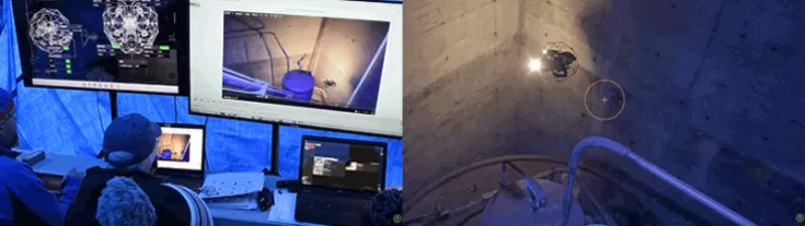
A total of about 50 people supported the operation that day. A large tent was erected over the entrance to the warehouse to ensure that the drone always flew inside the warehouse, in accordance with FAA (Federal Aviation Administration) regulations and Department of Energy requirements. A crane was also used to lift the heavy concrete cover off the warehouse and then open a hatch leading directly into the vault.
Finally, the storage facility was ready for flight. The flight was a success, and after just a 7-minute flight, the IEC team was able to collect all the LiDAR data they needed to map the interior of the storage facility. Given the time spent preparing the storage facility, a second flight was conducted to collect additional LiDAR data - this flight was also successful.
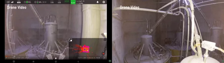
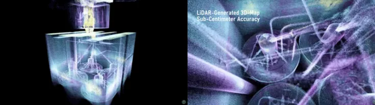
After each measurement, the LiDAR data was immediately processed using Flyability's Inspector 4.0 software and GeoSLAM's GeoSLAM Connect. The resulting 3D models were detailed and accurate enough to meet IEC's requirements and continue planning for the retrieval of nuclear waste from the repositories. After over a year of planning and preparation, the IEC team received everything they needed in their first seven-minute flight.
TitleAdvantages of scanning with a drone
Here are all the benefits the IEC team achieved by using the Elios 3:
- The best tool for the job – After extensive research, the IEC, working for the Department of Energy, determined that the Elios 3 was the best option for 3D mapping the interior of an underground nuclear waste repository.
- Detailed 3D mapping – The Elios 3 produced a high-quality 3D map of the repository, providing the level of detail needed to plan the disposal of the nuclear waste.
- Speed – In the first 7-minute flight, the IEC was able to collect all the LiDAR data it needed to map the interior of the repository in 3D, culminating in over a year of research and preparation.
- Access – The Elios 3 fit through the hatch, providing critical access to the repository for data collection.
- Ease of use – Despite adverse conditions, the Elios 3 flew as expected and was so powerful that it collected all the required LiDAR data in just two seven-minute flights.
After two successful LiDAR measurement flights, the IEC conducted a third test flight with one of its own dosimeters attached to the drone, significantly increasing its weight. For reasons not fully understood, the drone was unable to generate sufficient lift to maintain altitude after entering the vault during this flight. It slowly descended onto one of the storage containers and became entangled in a piece of angle iron.
All attempts to free the drone were unsuccessful. Before its battery was depleted, the drone was able to transmit a maximum radiation reading of 7 Gy/h (700 rad/h) at the top of the container. ICP experts conducted a comprehensive analysis and concluded that the drone's continued presence on the storage container posed no threat to human safety or the integrity of the storage container.
What happens next?
After successfully mapping the repository, the IEC team will proceed with planning the emptying process using the pneumatic tube system described above. Ultimately, all six casks must be cleared of their nuclear waste, an intensive task requiring several months of planning. This work is scheduled to begin in mid-2023. Given Elios 3's success in mapping the repository, the IEC and DOE plan to use the system again if other 3D remote mapping is required for confined space work.
Want more information? Contact us!
You can read the original article from Flyability here: ELIOS 3 USED TO 3D MAP IRRADIATED STORAGE VAULT AT DOE SITE