Documentation of an campsite in 3D

TitleState-of-the-art site documentation using the example of a renowned tourist campsite in Rovinj
Located on Croatia's enchanting Istrian peninsula, amidst the tourist hotspots where the Adriatic coastline unfolds its beauty and historical sites like the Game of Thrones film sets in Dubrovnik capture attention, tourism in Croatia has experienced an explosion of growth, making it a cornerstone of the economy.
The Maistra Group, as one of the leading players in the Croatian tourism sector, plays a key role in increasing the country's attractiveness. Managing 18 hotels, 11 holiday villages, and 6 campsites in popular destinations such as Rovinj, Vrsar, Zagreb, and Dubrovnik, the company faces the challenge of efficient and up-to-date site documentation. In 2021, the Maistra Group approached the Croatian GeoSLAM dealer Geo-Centar with the task of precisely surveying one of its campsites in Rovinj using modern techniques.
TitleSurveying with the ZEB Horizon from GeoSLAM
The surveying method chosen was as innovative as the objective: Geo-Centar opted to use GeoSLAM's ZEB Horizon in combination with aerial photogrammetry. The goal was to create comprehensive site documentation that included not only 2D vector maps and high-resolution 2D raster maps, but also georeferenced imagery and a digital terrain model with contour lines. This documentation serves as a valuable reference for future planning processes, given the campsite's age and need for modernization.
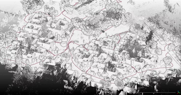
The size of the site to be surveyed, an impressive 1,100 m x 700 m, required a method that was both fast and precise. The Geo-Centar team used the walk-and-scan method with the ZEB Horizon, which not only enabled effortless data collection but also represented a significant increase in efficiency compared to alternative scanning methods.
“The ability to scan on foot is a real blessing in such situations, as any other scanning method is either much slower or much more expensive.”
A total of 10 scans were conducted, focusing on buildings, overgrown terrain, and other objects that would be difficult to capture with conventional aerial photography. Each scan, lasting approximately 20 minutes, allowed the team to capture the entire area in just over 3 hours, accurately identifying roads, sports fields, fences, stairwells, and paths.

TitleFurther processing of the scan data after the measurement
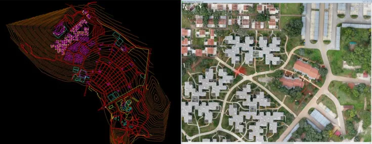
After the scanning process came the post-scan analysis phase. A GNSS receiver was used for surveying purposes to ensure accurate georeferencing of the data. GeoSLAM software was used to correct any possible deviations during the scan and provide accurate, high-quality data. In parallel, the images captured during the scan were georeferenced in GeoSLAM Draw and exported as an HTML version of the plan view. This version allowed for easy sharing with investors and engineers working on the same project and provided an overall visual impression.
The point cloud data was finally exported to third-party software, which the team used to create the necessary documentation and maps.
TitleUse of the documentation
The results of the survey were groundbreaking. The Geo-Centar team was able to comprehensively map the campsite and extract the necessary data to create high-quality survey maps, a digital terrain model, and precise elevation profiles. This data now serves as the basis for the planned modernization of the campsite. A clear example of how advanced surveying technologies can not only increase efficiency but also lay groundwork for the future.
The GeoSLAM ZEB Horizon is not available. The new generation of mobile laser scanners is now available from us.
The original article was written by GeoSLAM.