Creation of digital stadium tour with 3D mesh - MDCC-Arena Magdeburg

TitleWir auf dem Platz und Ihr auf den Rängen
Um eine 3D-Tour durch die MDCC-Arena, Heimspielstätte des 1. FC Magdeburg, zu erstellen, musste das Stadion digital erfasst werden. Dabei sollte der komplette innere Bereich des Stadions mittels terrestrischer 3D-Laserscanner erfasst werden, um einen digitalen Zwilling (Digital Twin) erstellen zu können. Zusätzlich zu den Laserscandaten sollten mehrere 100 Panoramaaufnahmen mit der Ricoh Theta Z Kamera erstellt werden. Ziel war es, im Anschluss die gewonnenen Laserscanning-Daten und die Panoramabilder mit der Software von Benaco zu verarbeiten, in ein 3D-Mesh zu verwandeln und eine komplette virtuelle Stadiontour zu erstellen. Diese soll es einerseits ermöglichen, die MDCC-Arena zu erkunden, aber auch im Zusammenhang mit Spielen den Besucher bei der Platzwahl zu unterstützen.
TitleEquipment & Software
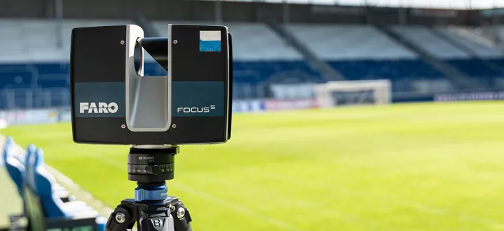
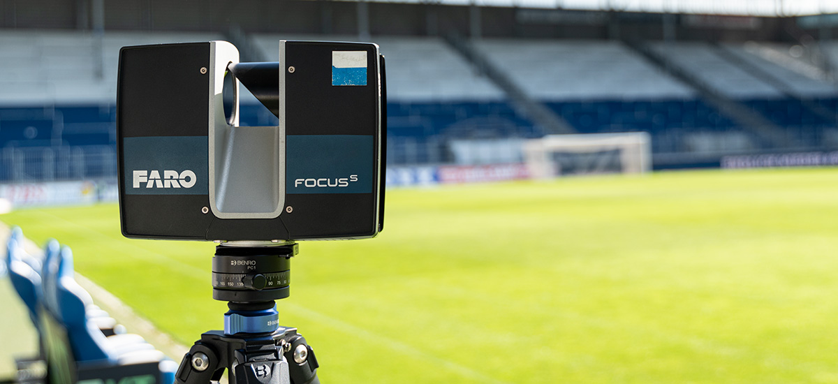
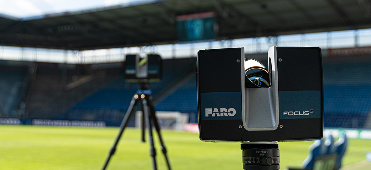
Zur kompletten Erfassung des Stadions mit allen Rängen, natürlich inklusive dem Spielfeld, wurden zwei terrestrische 3D-Laserscanner vom Typ FARO FocusS 70 und FocusS 150 eingesetzt.
Der terrestrische 3D-Laserscanner FARO FocusS 150 bietet hierbei optimale Voraussetzungen. Durch seine große Scan-Reichweite, die Schnelligkeit und extreme Genauigkeit ist dieses System prädestiniert für ein solches Anwendungsszenario. Die Scanner wurden dabei auf unseren leichten und robusten Carbon-Stativen montiert.
Für die Bildaufnahmen der späteren digitalen Stadiontour wurde zusätzlich noch eine 3D-Panoramakamera "Ricoh Theta Z" eingesetzt. Zur Nachbearbeitung der Scandaten wurde hierbei die Software FARO Scene verwendet. Mit der Software lassen sich die erfassten Daten im Anschluss an das Projekt schnell und einfach für die Weitergabe prozessieren.
Die Erstellung der digitalen Stadiontour fand anschließend in der Software Benaco statt, in der die Laserscandaten mit den Kameradaten zu einem 3D-Mesh vermascht wurden.
TitleAblauf der Vermessung

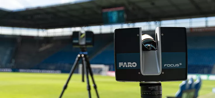
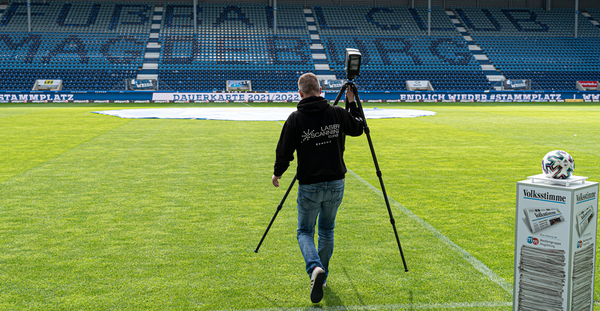
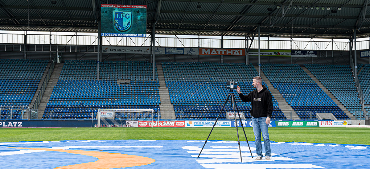
Zur Erfassung des Stadions musste der komplette innere Bereich des Stadions erfasst werden – zentral gelegen natürlich das Spielfeld, alle Blöcke inklusive der Logen bis zum Dach der MDCC-Arena. Mittels der beiden terrestrischen 3D-Laserscanner FARO FocusS ließ sich diese komplexe Aufgabe gut realisieren. Natürlich war es dabei wichtig, das Stadion von möglichst vielen unterschiedlichen Postionen zu erfassen, um eine hohe Überlappung der Scans für die Cloud2Cloud-Regsitrierung zu gewährleisten. Dazu wurden die Scanner jeweils auf drei verschiedenen Höhen rundherum im Stadion platziert.
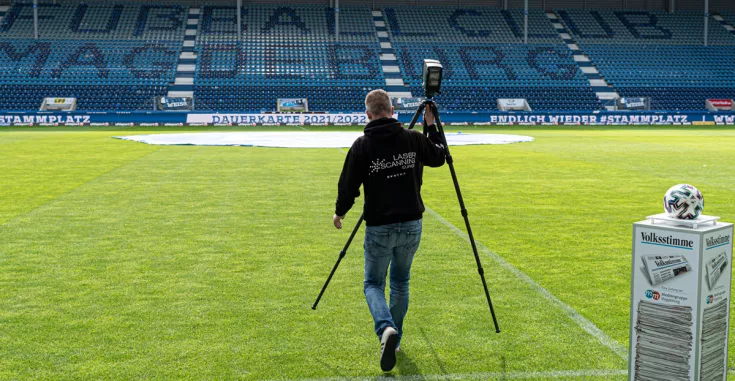
Vom Spielfeld, dem tiefsten Punkt, über die Mitte der Ränge bis zur obersten Reihe wurde so das komplette Stadion erfasst. Dank der eingesetzten robusten und leichten Carbon-Stative war es leicht, die 3D-Laserscanner auf den Stufen der Ränge fest und sicher zu platzieren. Aber auch beim Wechsel der Scan-Positionen boten sie durch ihr geringes Gewicht einen enormen Vorteil. Dies ermöglichte eine lückenlose und umfassende Erfassung des inneren Stadionbereichs. Während der Erfassung des Stadions mittels der 3D-Laserscanner wurden gleichzeitig von einem Mitarbeiter der Firma Benaco über 700 Panoramabilder aufgenommen. Diese speziellen 360°-Bilder ermöglichen es später, die MDCC-Arena aus allen Winkeln zu betrachten.
Durch die parallele Erfassung mit zwei Laserscannern und einer Panoramakamera dauerte die Aufnahme der Daten lediglich 6 Stunden.
TitleWeiterverarbeitung der Scandaten
Die erfassten Scandaten der 3D-Laserscanner wurden anschließend in der Punktwolkensoftware FARO Scene prozessiert. Die erfassten Daten konnten dabei schnell und automatisiert miteinander verknüpft werden. Mit wenigen Klicks und geringem Aufwand ließ sich so aus all den einzelnen Scans schnell die MDCC-Arena erkennen.
Kleine Anpassungen und gegebenenfalls Korrekturen lassen sich dabei leicht vornehmen. So konnten die 3D-Laserscandaten bzw. das Modell der Arena in kurzer Zeit an Benaco weitergegeben werden. Die exportierten 3D-Laserscan-Daten wurden anschließend mit den Panoramafotos in der Software Benaco verarbeitet.
Benaco ist eine Lösung zur Erstellung realistischer und genauer 3D-Modelle (3D-Mesh). Die Software verarbeitet farbige Punktwolken – für eine hohe Genauigkeit am besten von terrestrischen Scans und Panoramafotos jeglicher Art. Die Panoramafotos werden dabei via Photogrammetrie automatisch an den kolorierten Laser-Daten ausgerichtet. Durch die hochqualitativen Panoramabilder lässt sich maximales Fotodetail erreichen.
Image 
We on the court and you in the stands
Mission
In order to create a 3D tour of the MDCC-Arena, home ground of 1. FC Magdeburg football club, the stadium had to be digitally captured. The complete inner area of the stadium was to be captured by terrestrial 3D laser scanners in order to create a digital twin.
In addition to the laser scan data, several hundred panoramic images were to be taken with the Ricoh Theta Z camera. The aim was to subsequently process the captured laser scanning data and the panoramic images with Benaco's software, to transform them into a 3D mesh and to create a complete virtual stadium tour. On the one hand, this will enable visitors to explore the MDCC-Arena, but on the other hand, it will also help them to choose their seats for matches.
Equipment & Software
Two terrestrial 3D laser scanners of the type FARO FocusS 70 and FocusS 150 were used for the complete capture of the stadium with all stands, of course including the playing field.
The terrestrial 3D laser scanner FARO FocusS 150 ensures optimal conditions. Due to its large scanning range, speed and extreme accuracy, this system is predestined for such an application scenario. The scanners were mounted on our lightweight and robust carbon tripods.
A 3D panorama camera "Ricoh Theta Z" was added for the image captures of the later digital stadium tour. The FARO Scene software was used to post-process the scan data. With this software, the captured data can be processed quickly and easily for sharing after the project.
The digital stadium tour was then created in the Benaco software, in which the laser scan data was meshed with the camera data to create a 3D mesh.
Procedure of the scanning
In order to survey the stadium, the complete inner area of the stadium had to be captured – centrally located, of course, the playing field, all blocks including the boxes up to the roof of the MDCC-Arena. This complex task could be realized successfully by means of the two terestrial 3D laser scanners FARO FocusS. Of course, it was important to capture the stadium from as many different positions as possible to ensure a high overlap of the scans for Cloud2Cloud registration. For this purpose, the scanners were each placed at three different heights all around the stadium.
From the playing field, the lowest point, through the middle of the stands to the top row, the entire stadium was thus captured. Thanks to the robust and lightweight carbon tripods, it was easy to mount the 3D laser scanners firmly and securely on the steps of the stands. But their light weight also offered an enormous advantage when changing scan positions. This enabled a complete and comprehensive capture of the inner stadium area. While the stadium was being scanned by the 3D laser scanners, over 700 panoramic images were simultaneously taken by a specialist from Benaco. These special 360° images later made it possible to view the MDCC-Arena from all perspectives.
Due to the parallel capture with two laser scanners and one panoramic camera, the data acquisition took only 6 hours.
Further processing of the scan data
The collected scan data from the 3D laser scanners were then processed in the point cloud software FARO Scene. The captured data could be merged quickly and automatically. With just a few clicks and little effort, the MDCC-Arena could thus be quickly spotted from all the individual scans.
Small adjustments and, if necessary, modifications could be easily made. In this way, the 3D laser scan data or the model of the arena could be passed on to Benaco in a short time. The exported 3D laser scan data was then processed with the panoramic photos in the Benaco software.
Benaco is a solution for creating realistic and accurate 3D models (3D mesh). The software processes color point clouds – preferably from terrestrial scans and panoramic photos of any kind to ensure high accuracy. The panoramic photos are automatically aligned to the colored laser data via photogrammetry. The high quality panoramic images allow maximum photo detail to be achieved.
The final result: An impressive 3D tour of the stadium
The final result is impressive!
The combination of 3D laser scans and high quality panoramic images allows unique results. Thanks to the Digital Twin, we have an exact image of the stadium. Every user can view the result directly in the browser; no special software is required. Integrating the tour into the website and app of 1. FC Magdeburg was also very easy.
The 3D tour can be used, for example, to revolutionise seat selection and ticket purchasing. Via iFrames, a ticket booking could be integrated directly into the stadium tour via Eventim, for example, so that stadium visitors could buy a ticket for their current seat in the stadium from within the tour. Other interactive possibilities also open up, such as the integration of special videos or images generated by fans during a match.
The best way to experience the 3D stadium tour through the digitized MDCC-Arena is simply to go there yourself:
Questions? Call us now!
+49 391 62 69 960 | +49 7153 66 29 112 | +49 2151 60 32 955
Want to request by mail?