New mobile solution for terrestrial scanning from Emlid and PIX4D
New mobile terrestrial scanning solution from Emlid and Pix4D to speed up data capture in construction, utilities and more
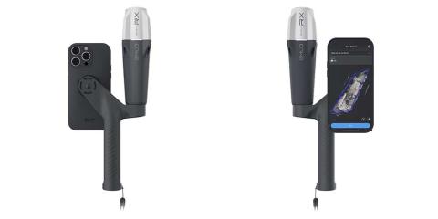
To simplify and speed up complex workflows between the field and the office, Emlid and Pix4D are launching a mobile scanning kit that allows anyone in the team to capture precise digital scans using their smartphone, the PIX4Dcatch app and the Emlid Reach RX rover.
We have tested the new solution from EMLID and PIX4D and are now offering it for sale. Curious? Then take a look at the simple workflow and the results in the video!
Plug & play: fully integrated and easy to use solution
At the heart of the software part of the kit is the recently enhanced PIX4Dcatch app, which enables precise scanning for both photogrammetry and LiDAR projects. The hardware part consists of the Emlid Reach RX GNSS Rover, which is equipped with an ergonomic handle and accessories.
In combination with a LiDAR-enabled smartphone, such as the iPhone Pro, the kit is a practical and cost-effective scanning combination for teams and individuals.
Emlid Reach RX is natively integrated with PIX4Dcatch and offers real-time positioning via NTRIP. To start scanning, simply select Emlid in the RTK settings of PIX4Dcatch and add your NTRIP network credentials.
The solution's design eliminates the need to set up additional hardware or specialized knowledge. Anyone in the team can use the kit, ensuring effective data capture as they move around the facility.
To ensure good handling, the Pix4D & Emlid Kit comes with a handle that is shaped to fit comfortably in the hand. The handle is suitable for both right and left-handed users.
Proven workflows in various industries
The Pix4D & Emlid Scanning Kit is easy to implement yet highly accurate. It is highly useful for professionals and non-surveyors in a range of applications:
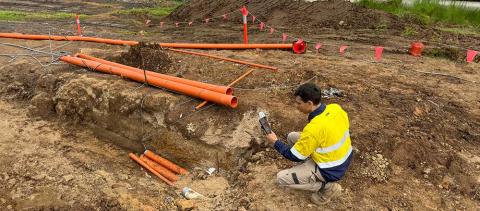
- Underground utility documentation and as-built surveys for organizations using subsurface utility engineering (SUE) best practices.
- Construction inspection – As-built scans for design plans and to expedite permitting.
- As-built surveys – Better as-built surveys with less time spent on data collection and drafting.
- Volumetric measurements – Effortless determination of stockpile volume.
- Accident reconstruction – Perfect for clearing roadways quickly with simple, accurate scans.
- Combined drone and telephone surveys – Complement overhead drone surveys with terrestrial PIX4Dcatch scans.
Hardware: Top-class GNSS from Emlid
The Emlid Reach RX works with any correction network (NTRIP) or GNSS base station transmitting RTCM3. The rover obtains a locate point in less than 5 seconds even under difficult conditions and ensures centimeter-accurate positioning.
In addition to scanning tasks, it can be used with the survey rod as an RTK rover for data acquisition and staking out.
The RX was developed for urban surveying and has the following specifications:
- With an IP68 rating, the Reach RX is water and dust resistant.
- The receiver weighs 250g and can be carried in a pocket.
- The industrial-grade battery can withstand both high and low temperatures and offers 16 hours of operating time with a charging time of less than three hours. You can charge it on the go via any USB port or power bank.
Software: Powerful data capture & photogrammetry from Pix4D
With the PIX4Dcatch mobile app, you can scan with a smartphone, get precision data thanks to integration with Reach RX RTK and create a digital model in minutes.
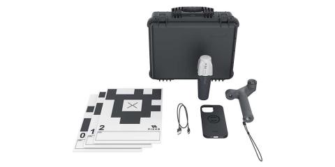
With the standard Pix4D & Emlid Scanning Kit, you can store the data online in PIX4Dcloud, annotate, measure and share it with stakeholders. You can also verify georeferenced positions and visualize the project in augmented reality.
The Advanced Pix4D & Emlid Scanning Kit goes even further and allows you to analyze and evaluate terrestrial and aerial data. By combining PIX4Dmatic and PIX4Dsurvey, it enables online and offline processing, advanced photogrammetry functions, team collaboration and AR for CAD overlays.

Combined UAV and cell phone surveying with Pix4D photogrammetry products.
Buy PIX4D & EMLID Scanning Kit Standard Buy PIX4D & EMLID Scanning Kit Advanced