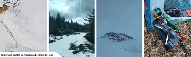
Avalanche surveying in the French Alps

TitleInfluence of surface roughness on the Earth's radiation budget: New findings from climate research
Climate change is often attributed to greenhouse gases; however, there are other factors that also influence Earth's climate. One example is the Earth's radiation budget. The Earth's radiation budget is the energy that enters Earth's atmosphere and is reflected, absorbed, or emitted by our planet. If the balance of the budget is disturbed, it can cause a rise or fall in temperature in Earth's atmosphere.
A team from the Institut de Physique du Globe de Paris (IPGP), a world-renowned geoscience organization, has conducted research in this area. Their research focuses on how differences in surface roughness affect the amount of microwave radiation detected by satellites.
Investigation of the surface roughness of snowpacks and avalanches in the Vanoise Massif
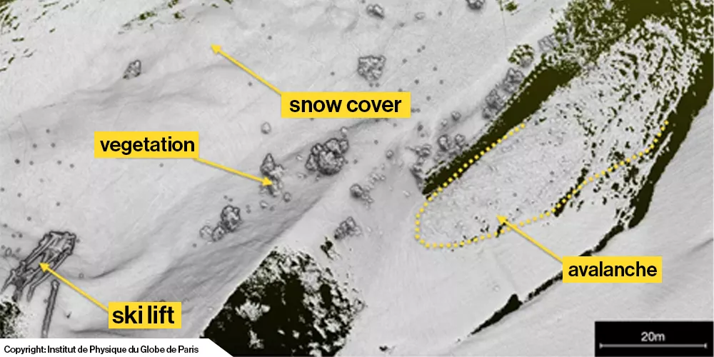
For their research, the team focused on snowpack and avalanches in the Vanoise Massif. The goal was to compare the two satellite images to evaluate the effect of changing surface roughness on avalanche formation using radiative transfer models. This is a process that measures solar radiation into and out of the Earth. High solar radiation can lead to snowmelt, which in turn can trigger avalanches.
The Vanoise Massif is located in the Granian Alps in the Savoie region of France. It is the third-highest massif in France, reaching an elevation of 3,885 meters with the Grande Casse peak. This mountain range is home to France's first national park, the Vanoise National Park.
Recording the dangerous and difficult-to-access environment of the mountain range
To collect data on snowpack and avalanches, the team needed a precise 3D model of the area. Vanoise National Park is a no-fly zone, meaning drones weren't an option. Furthermore, the team didn't want to spend extended periods on the mountain due to the avalanche risk. This ruled out more time-consuming scanning methods, such as terrestrial laser scanners.
Therefore, the team needed a more efficient method to map the challenging terrain. The team decided that SLAM was the best option and opted to use GeoSLAM's ZEB Horizon backpack solution.
TitleSafe mapping of avalanches in the Vanoise massif with the mobile scanner ZEB Horizon
The IPGP team was impressed by the ease of use and versatility of the ZEB Horizon. The unique characteristics of the environment required the use of technology that was both lightweight and robust. Furthermore, the backpack solution was crucial, allowing the person performing the scan to have their hands free to move around the rugged terrain.
Furthermore, thanks to the ZEB Horizon's high acquisition speed, the team was able to scan the 3,000 square meter area in approximately two hours. This ensured that the team didn't spend too much time in the dangerous mountainous terrain while still being able to capture the required accurate data.
TitleCreation of precise data for IPGP research
The scan was processed using GeoSLAM software. The resulting point cloud will be integrated into IPGP's research analysis and modeling.
The ease of use and accuracy of the ZEB Horizon allow the scan data to be compared with data collected from satellite observations. This is known as ground-truth analysis and contributes to clarity in research.
The scan data also supports data calibration, allowing atmospheric influences and confounding factors to be taken into account when analyzing the final data. The positive data results have encouraged the Institut de Physique du Globe de Paris to plan further research in this area.
GeoSlam scanners are no longer available. We offehttps://shop.laserscanning-europe.com/Mobile-Laserscannerr next-generation technology. Please contact us if you have any questions.
Original article by GeoSLAM.