Laser scanning user stories

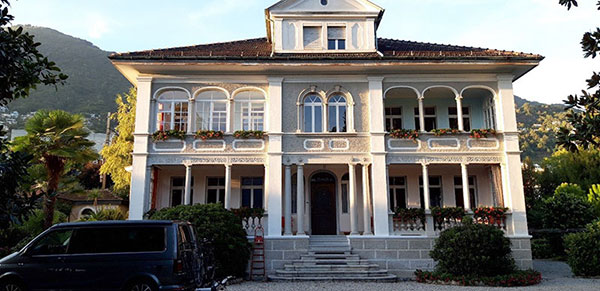
Scanning of a villa in the canton of Tessin for a rehabilitation concept & a virtual tour

Some time ago, we had a special scanning training in beautiful Tessin (Switzerland). The aim was to capture a stately villa from the early 20th century and the surrounding magnificent garden in three dimensions. The documentation provided the basis for a renovation concept. The training participants also created a virtual tour based on the scan data.

2D modelling vs. 3D modelling for as-built capture

Time is changing. While in many areas people still work in 2D, others have recognised and implemented the advantages of 3D modelling long ago. Especially in the fields of industry and automotive engineering, 3D modelling has become firmly established and is constantly developing.

In architecture, we are experiencing a rather timid change. The 2D analyses of floor plans, sections and views are a familiar and firmly rooted basis for creative planning and conversion work. Ideas are developed on sketch paper, materials are assigned, rooms are furnished – and then digitally implemented.

We are often asked where the real added value of a 3D model is? Where exactly are the advantages or disadvantages of 2D or 3D modelling and which variant should you use in your next project?


Process optimization with the help of 2D hall plans

We were asked to support a leading manufacturer of roller shutters and sun protection systems in optimizing its production processes. Current hall layouts were to be drawn up containing all machines, storage positions and other inventory. These serve as data basis for a potential production optimization. The production of the roller shutters and sun protection systems is located in four halls on a total area of around 4,000m².

Sketched plan - Hall 1


DTM creation of a quarry from UAV data and comparison with existing models

The waste disposal company of the city of Mainz authorised us to work on an exciting project. Within the scope of the project, we received photogrammetric data of the quarry Mainz Laubenheim. The aim was to create a digital terrain model (DTM) from a point cloud, which the company LOGXON GmbH & Co. KG had previously generated by a drone flight.

Aerial image of the quarry


Planning in harmony with the surrounding environment

One of the jobs of a planner is to present a renovation, new construction planning or building extension in a simple, fast and realistic way to his customers. Many planning models already exist in 3D and are stylistically prepared and embellished for presentation purposes. But what does the planning look like in the real world? Does the new building fit into an existing development area? How is the height development? What are the dimensions? Where are light and shadow conditions caused? And which building materials fit best into the surroundings? All these questions can be easily clarified and visualized with the combination of 3D model and as-built scan (point cloud).


Volume determination for inventory purposes by means of laser scanning

Within the scope of a project, we were able to help to significantly speed up and precise inventory work by using the scanner. The materials in question were minerals that were deposited in pits, storage boxes and storage halls, both indoors and outdoors. According to the customer, the volume determination was very complex in the past. A rough dot matrix was measured manually on the surfaces of the mineral resources. This process took about two weeks with the number of piles; with the help of the ZEB-Horizon the time required was reduced to one day. In addition, the points are also finally much more dense, so that the results are more precise.

Mound


Testing of LSE reference spheres regarding their usability with the Leica RTC360

As part of an investigation, we tested various reference spheres for their behavior with the Leica RTC360 laser scanner. The key question was whether owners of the RTC360 can use the reference spheres with their hardware and software. To allow an evaluation, different criteria were set up.

Standard deviation values were compared with regard to the quality of the sphere's fitting. Another interesting aspect was the investigation of how many points at what distance can still be used for calculation. Whether the fitting of the spheres is carried out automatically or is possible at all was also tested in various software solutions.

leicaRTC360_Test


Scanning and modeling of the theatre stage Senftenberg

3D models are not only used in the architecture of residential and industrial buildings to serve as a basis for planning and refurbishment work. Three-dimensional models have also found their way into art and culture, such as the theatre.

Together with Knispel surveying office, Laserscanning Europe GmbH has scanned and modeled the stage area of the new stage in Senftenberg (Germany). Read the entire report to find out which scanner and software were used for this purpose.

3D model theatre stage