Davinci Copters ScaraBot X8
Lightweight - flexible - efficient
The powerful ScaraBot X8 of Davinci Copters is our choice for surveying with drones. Developed and manufactured in Germany, the ScaraBot X8 is a multicopter system with excellent flying times and provides numerous applications. The RTF ("Ready To Fly") UAV is manufactured in high-quality single-piece production to provide you with a reliable device that even meets the highest quality demands.
5kg flying weight - Fly only with a general start permission
Especially due to the low flying weight under 5kg, the ScaraBot X8 is the perfect solution for your captures from the air. In Germany, you only need a general start permission for this system!
Request more information now ►
General information abour surveying via drones ►

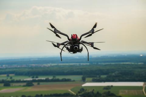
The UAV with maximum efficiency
Survey 50 hectares in just 40 minutes
Thanks to its intelligent lightweight design and the specially developed Free Flow Arms (booms with streamline shape), you maximize efficiency with this UAV. The octocopter with camera makes it possible to capture up to 50 hectares from the air within 40 minutes. The high-quality components, such as the highly efficient engines and the custom-made high-performance batteries, allow such long flying times. Quality: Made in Germany.
The ScaraBot X8 has all professional standards as is the case with UAVs offered by other manufacturers. But the UAVs of Davinci Copters additionally meet demands such as maximum efficiency, failure safety and system integration.
Request more information now ►

The all-in-one solution
Benefit from the bundle of hardware, software, training and service
Our aim is not to offer you just a drone and leave you alone with it. We offer you instead an all-around carefree package, that means a perfect solution combining hardware, software, training and service. With us on your side, you get professional advice.
Without experience and background knowledge, you don't have the required know-how to fly a drone professionally and to create a point cloud based on the data. That's why you learn in our training the handling of drones and their flight characteristics. Our experienced trainers practice with you in the field how to control the drone and to react in a deficiency situation. In order to generate useful results based on the drone data, you learn how to create and analyze point clouds using the offered software. We provide you with everything you need.
Request more information now ►

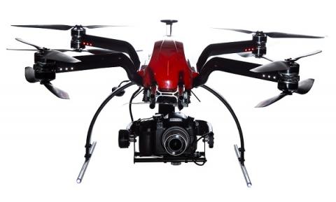
ScaraBot X8 with camera
Perfect for all circumstances
Drones are a modern and innovative tool for various applications related to commercial or civil use. With drones, you reach places that are otherwise only accessible with difficulties and at great expense. Simply use drones to capture buildings and landscapes from the air - With ScaraBot X8, you look at the world from another perspective.
Due to its excellent flying times, ScaraBot X8 is suited for numerous fields of applications:
- Photogrammetry
- Aerial photos
- Flight planning
- 3D maps
- 3D terrain models
- Inspection
- Surveillance & search flights
- Fire service (overview from a bird's eye view, find hot spots, fawn rescue)
- Visualization and surveying of infrastructure
- Resource management
- Agricultural economics
- Forestry
- Planning of construction projects
- Constructions of roads, tunnels and train paths
- Civil protection
- Video production
Based on the georeferenced drone data, you can create 3D terrain models which contain all georeferenced data to calculate volumes, surfaces and distances.
Request more information now ►
General information abour surveying via drones ►

3D DTMs (digital terrain models) via photogrammetry
Long ranges within a minimum of time
Due to the long flying times of ScaraBot X8, you extend the range for captures and thus distance and surface. With attached camera and only one battery, you can fly over up to 50 hectares. When you choose an autonomous route navigation (waypoint navigation), taking the photos can be made automatically in a defined grid.
On the basis of drone data, you can create 3D models of the area and process them as desired.
Request more information now ►


Drones for aerial photography
Long flying times for optimal results
You need great flying times even for aerial photos, for example when you are waiting for this one second with the optimum light at sundown. Or when you want to take photos of large objects from different directions and find the best perspective for each photo.
Request more information now ►

Drones for inspection
Gain insights without safety risk
Play it safe and examine high buildings free from dangers by means of camera shots. This way, you don't need to climb up anywhere or put up a scaffolding. The use of drones is especially suited for inspecting industrial facilities.
Request more information now ►

Mode of operation of drones
The comfortable way tp capture data
ScaraBot X8 allows you to create a flight plan in advance and easily start the automatic flight at the push of a button. But you can optionally control the drone from the ground via GPS.
By means of the software solutions Agisoft and PointCab, you can create a point cloud based on the georeferenced data and a 3D terrain model afterwards. Then, you can derive lengths, surfaces or volumes for the 3D data.
Request more information now ►

Specification of Davinci Copters ScaraBot X8
The compact UAV with strong performance
The ScaraBot X8 convinces users not only by its small dimensions and the low weight but also by the custom-made high-quality engines and the specially developed high-performance batteries. The intelligent design with booms with streamline shape allows best flying times.
Request more information now ►

Technical specifications
All data at a glance
ScaraBot X8 has the following characteristics:
- Octocopter
- Full carbon fiber frame with "Free Flow Arms" for better efficiency and longer flying times
- Flying weight: < 5 kg
- Center distance: 500 mm
- Hood painted red
- Herkules III controller
- Herkules telemetry board
- Herkules anti spark
- iOSD Mark 2
- Elaborate LED lighting
- DJI Wookong with optional waypoint navigation
- Extensive telemetry system with recording off light data
- GPS Position Hold, Coming Home, Failsafe, Altitude Control
- Jeti remote control DC-16 Duplex
- Live image monitor with integrated Diversity receiver
- Brushless Gimbal BLG600: laminated 2-axis CFRP Gimbal with Brushless system and AlexMos control for system cameras till 600g
- Mounting tubes for various gimbal systems (EasyPlug quick-change system)
- Two lithium ion batteries with protective circuit (flight battery 18 V, 20300 mAH) included
- Camera Sigma DP 1 with lens included
- Solid lockable wooden box with metal fittings, grips, wheels included; inside all faces cushioned
Output formats
The perfect format for your application
In order to generate the desired results on the basis of the drone data, the software solutions Agisoft uand PointCab are perfect. Agisoft creates point clouds based on the captured data. With PointCab, you can analyze and process point clouds afterwards. Thus, you can create 3D models and ortho photos or calculate surfaces, for instance.
The following output formats are available:
- 2D ortho photos (.jpg / .tif / .png / .kmz)
- Point clouds (.obj / .ply / .text / .las / .u3d / .pdf)
- 3D models (.obj / .3ds / .wrl / .dae /. ply / .dxf / .fbx / .u3d / .kmz / .pdf)
- DEM (.tif / .asc. / .bil / .xyz / .kmz)


Questions or interest
Better informed as a user
Are you interested in our offer or do you want to get more information about ScaraBot X8? Simply call us today and fix a free and non-binding consultation appointment. We will respond to all your questions. As dealer and user at the same time, we are perfectly prepared to support you even after purchase.
Call us immediately!
Phone: +49(0)7153 - 92 95 93 20
Request your quote online even today!
Request a quote now